RJP
-
Posts
18 -
Joined
-
Last visited
Content Type
Profiles
Forums
Events
Gallery
Downloads
Everything posted by RJP
-
Hi All, I recently created an Excel version of most of the output from running makerwys on a default FSX installation (with taxiway info excluded). Many thanks to Pete, both for creating makerwys / FSUIPC and also for being kind enough to upload the file which is available via the following link; http://fsuipc.simflight.com/beta/Airport_Runway_Parking_Com.zip Best regards Richard
-
MakeRwys Closed Runways / Short Runways
RJP replied to RJP's topic in FSUIPC Support Pete Dowson Modules
Hi Pete, Hopefully the train holiday was good? Many thanks for looking into it! In at least some cases yes, I believe this is the case. I wondered about AK02 but that's less than 1503 (see below). Ah, I see (& I also see the W on the runway designator now, I really should have done so previously, sorry). Hmmmm, I've just tried re-running (with />10) and the shortest I get is 1503, almost as though the switch is not being considered. I've just tried />500 too and the shortest I get is still (oddly!) 1503. Wonder if it can be a system related issue? FYI I'm using Win10, with command prompt run as admin. Many thanks again Pete, yep I'm thinking now that as opposed to there being anything 'wrong' that for some reason the length switch is being ignored when I run, I wouldn't have a clue either why or how to confirm / workaround though. Best regards Richard -
MakeRwys Closed Runways / Short Runways
RJP replied to RJP's topic in FSUIPC Support Pete Dowson Modules
Thanks Pete, On it's way to you... Best regards Richard -
MakeRwys Closed Runways / Short Runways
RJP replied to RJP's topic in FSUIPC Support Pete Dowson Modules
Hi Pete, Just cleaned up the file for upload...... Unfortunately though it's still 11.5mb so way over the attachment limit size. Is there any other way to upload / share it? Best regards Richard -
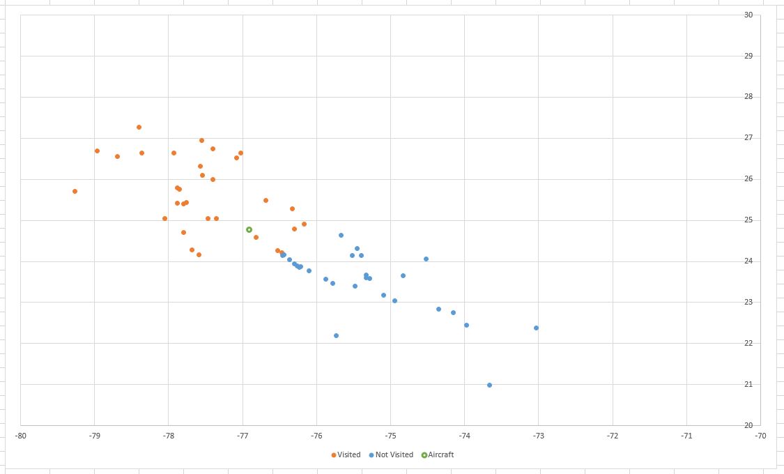
Hi, Following on from me asking about getting (regularly updated) data from FSX to Excel I thought I'd attach an example of what I've done, just in-case it's of any use to anyone here. The demo includes only data for the Bahamas, please ensure you're in that area. Open the file, ensuring that macros are enabled (see note below first). You'll be presented with a scatter graph, showing the lat / lon of airfields in the Bahamas, in effect a simplified map. The orange markers are those I've set to 'Visited' and blue are 'Non-Visited'. The red circle is the last logged aircraft position. Hover over a marker to see ICAO code, the country, the name of the airport and if it's logged as visited or not. Left click on a marker to change from visited to not-visited and vice-versa. With FSX and FSUIPC running and with the aircraft positioned within the Bahamas click the 'Start' button. The red circle will move to the correct lat / lon and thereafter will update once per second. Obviously the red circle will only move when FSX is not paused. The file contains the code from the visual basic FSUIPC SDK libraries. It was created in Excel 2016 but I believe will work in any version which the SDK VB code is compatible with. Please note: The attached file contains macros, they run successfully and without harm on my own PC. However, by running them you accept all resultant risks should there be an issue with them. Best regards Richard Map Demo.xlsm
-
Thanks Paul. Yep, very true.... After a few issues (probably caused by me), I'm getting decent results manipulating the autopilot too. I think once I've finished the initial project (Excel based map with ability to randomise flights (within distance & runway limitations) ) then I might look at something to provide guidance to airfields without nav-aids (to guide towards an extended centre-line). Best regards Richard
-
Using a list of airfields (filtered in this example to just the Bahamas) I created a scatter graph of locations (orange: those I've visited, blue: not visited) and also the aircraft position. It's working well, I've put the code which gets the aircraft position into a timer loop so it updates every second, sure enough I see the green circle move around the chart.
-
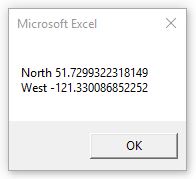
Well the lat / lon worked ok;
-
MakeRwys Closed Runways / Short Runways
RJP replied to RJP's topic in FSUIPC Support Pete Dowson Modules
Hi Pete, No probs! I've been a bit tied up for a few days but once I have some time I'll tidy the file up and post it. Best regards Richard -
Hi Pete, Thanks for the info! I couldn't get anywhere with the thought of using google maps in between FSX & Excel, however, see below. Hi Paul, Thanks for the info / link. The visual basic modules do indeed seem to work in VBA. Well with the code from one of the accompanying text files I was able to get the aircraft title into Excel. A simple bit of info yes but hopefully it means the other bits of info I need won't be an issue (lat / lon primarily, perhaps also altitude & speed). I had a quick try last night with altitude and couldn't get it to work but I believe it's just the format of how I'm calling the read function so as it's in VBA now I'm happy that I'll find / blunder my way to a solution. Best regards Richard
-
MakeRwys Closed Runways / Short Runways
RJP replied to RJP's topic in FSUIPC Support Pete Dowson Modules
Hi Pete, I managed to manipulate the info in runways.txt to create a spreadsheet with a listing of all airports, all runways (inc length / width, surface & including closed) & all comms data. I understand that the files that MakeRwys creates are intended for use in the like of ATC utilities so my file may be of no use but if it might be of benefit to someone please let me know & I'd be very happy to send it. Best regards Richard -
Hi Pete, Many thanks again for another speedy reply! Almost, I meant put the lat / lon (& any other info which might be available) into specific cells in an existing Excel file. I.e. that a single specific cell gets updated at intervals with the current lat (and a single specific cell for each of the other bits of data) (not that it records a series of locations a-la a flight recorder). Ah, by coincidence I've just been reading a few bits about Lua, I'll happily admit that most of it went straight over my head haha I'll look in more depth when I get a chance though, thanks for the info! Another option I thought of is if there is a way of passing a location to google maps in a browser? I've previously created an Excel tool for image cataloguing which would extract lat / lon from an images exif. If they weren't present then the user was given an option to open google maps, centre the map over the image location then return to the Excel file and the location would be taken from the browser address. Certainly nothing startling but it might be another way to get a lat / lon into what I'm trying to do. As someone who can blunder their way around VBA only, but with (usually lol) a bit of success do you think trying to do something with Lua to put the location straight into an existing Excel file or trying to put the location into a browser / google maps and read it from there would be the easier option? (For the second one if the location is in the browser address the rest is no problem). Best regards & many thanks Richard
-
Hi All, A slightly random question......... Is it possible for FSUIPC to pass a location to Excel? If any other variables (particularly heading & aircraft type and / or registration) could be passed also it would be ideal! It would be ideal if I could get the lat / lon into cells in Excel. If it's possible where might I find some pointers on how to start with doing so? Once I've got information into Excel I can handle it from there but would be lost with the bit before that (hence not knowing if it's even possible). Best regards & many thanks Richard
-
MakeRwys Closed Runways / Short Runways
RJP replied to RJP's topic in FSUIPC Support Pete Dowson Modules
Sounds great! Enjoy!! :) -
MakeRwys Closed Runways / Short Runways
RJP replied to RJP's topic in FSUIPC Support Pete Dowson Modules
Thank-you very much! :) Enjoy the travels! Anywhere nice? Best regards Richard -
MakeRwys Closed Runways / Short Runways
RJP replied to RJP's topic in FSUIPC Support Pete Dowson Modules
I -think- what's written to the XML might be the issue....... using "MakeRwys />0 /Water", in the text file for (eg) AK02 I get; whilst in the XML I get; For the first sample airport I was looking at (MYZ2, Cape Eleuthera) the txt IDs a closed runway (without of course the start & end points): Best regards Richard -
MakeRwys Closed Runways / Short Runways
RJP replied to RJP's topic in FSUIPC Support Pete Dowson Modules
Hi Pete, Many thanks for such a quick reply. Might it be possible to have a switch to select whether or not closed runways are included? According to a bit of googling it's TNCS (Saba, Netherlands Antilles) with 1,300 feet (evidently they're excluding the microlight fields). TNCS doesn't appear for me..... Don't be mad at me but....... If I don't use the Water switches (makerwys />0) then I get 2 runways included (well both directions of 1) at EDCY with a surface type of Water (the other water runways at EDCY aren't listed). If I include the Water switch (makerwys />0 /Water) then I get the same results. If I use makerwys />0 /WaterOnly I get the same (lots of runways, only 2 water). If I use makerwys /Water then I get plenty of water runways included (including the other ones at EDCY). MakeRwys /WaterOnly includes a gravel runway at IN53. For EDCY only 2 of the 4 water runways are listed. MakeRwys />5000 gives plenty of runways, including many under 5000'. Hope that doesn't cause grief? Thought it might be useful to list what I was / wasn't seeing. Best regards & again, many thanks Richard -
Hi, I've recently created a tool in Excel, using a table of ICAO ID, City, Region, Lat / Lon to produce a map of airports, coloured differently for those I've visited and those I haven't yet visited. The last logged airfield is identified along with the distance from that to each other airfield. I decided to add some functionality which would require other data such as runway surface, runway length (& ideally runway width, ILS provision etc). In trying to find that data I came across MakeRwys which seems to provide just what I need. I am having an issue though......... listing closed runways. Some airports in FSX in The Bahamas (just the area I'm looking at initially, there may be others) have only closed runways. An example being MYZ2 (Cape Eleuthera). I'd like to include closed runways in what I'm doing, the 'ClosedLanding' and 'ClosedTakeoff' fields in Runways.xml suggests that MakeRwys has the ability to list where either is 'TRUE'. Have a missed a command line switch to include them? Those fields are always only populated with 'FALSE'. I understand the need for the minimum runway length field, however, on the offchance that closed runways were listed with 0 length I set the switch to />0 (i.e. "makerwys />0"). The shortest runway in the results is 1503, should that be the case? (default FSX scenery library) Thanks and many thanks in advance for any advice Richard