
forstmeier
-
Posts
108 -
Joined
-
Last visited
-
Days Won
1
Content Type
Profiles
Forums
Events
Gallery
Downloads
Posts posted by forstmeier
-
-
FSUIPC7
Mainly the Autopilot commands via external software.
I note that several MSFS default airplanes either do not respond or only receive or transmit.
The Boeing 747-8 example. Before the last recent update the commands were responding, now some are not.
In FSX no problem.
With x-Plane it is not different.
A native FSX airplane suited for MSFS or X-Plane is working well.
The Simulator default aircrafts should be checked for use of FSUIPC7. It takes little to create a program that verifies the necessary Offsets and other manual commands that are not always responding as they should.
Maybe they focus too much on graphics.Raimund
. -
23 hours ago, jerryg said:
I show KLAX showing on my computer in fsx, but fsx isn't installed on my computer. When I go to steam and p3d sites, klax dosen't show as purchased. Can this be fixed?
A) I show KLAX showing on my computer in fsx
B) but fsx isn't installed on my computer
Fantastic.
Go to steam and p3d sites and make a specific search.
Raimund
Intrasystem
.
-
On 1/18/2023 at 12:37 PM, forstmeier said:
Just use search and type " Download XPUIPC ". The Interface between X-Plane and FSUIPC.
The Final,
obviously you must search with Google and google. It can't be here on this pages. XPUIPC is not FSUIPC or FSUIPC7.
-
On 11/13/2022 at 7:35 PM, Guest enur said:
Purchased and installed via Simmarket's installer.
At take-off, the aircraft steepens after a few meters on the runway.
And when starting on a custom mark, the plane goes into a spin.
(see attachment 2 pictures) Hope you can help me?
.thumb.png.14662ec433382d2e19893b95da43eb88.png)
.thumb.png.d7805a01074b3e83b99264032a32c5cf.png)
Do you think the Airspeed Knots of 57 is enough for a take off ? I guess it should be around 140 knots at least for this aircraft.
Same with your 1. image. Your speed of 76 ? Warning > STALL
When stall occurs, reduce angle of attack, roll wings level, and add power as needed. As flying speed returns, stop descent and establish a climb. Maintain climb airspeed, raise landing gear and flaps, and trim. Return to the desired flightpath.
I think you managed it meanwhile.
-
Just use search and type " Download XPUIPC ". The Interface between X-Plane and FSUIPC.
-
Sorry but i don't understand what you mean with " the sim data source thing ". There are many different Sim Data sources.
Which data should be contained in this " data source " ?
XPUIPC is on Top of this SimFlight Page.
Raimund
.
-
On 3/24/2022 at 7:55 PM, Pete Dowson said:
an do this for you if you prefer, with just a small edit needed to divorce it from this thread
Yes please. copy the part you think is useful.
Thanks
Raimund
.
-
Pete said:
"would you like to re-post this data to the "User Contributions"
-------------------------
Yes i will copy it there.
By the way. Tomorrow i will upload to my website the corrected ATIasHold Software.
Before doing the last 1.8.3 upload I saw a point in the program that seemed easy to change.
Mea culpa. (maybe the age)
I made a glamorous mistake as this small change affected at least 4 procedures and functions. In detail, the radar view of Adf + Vor in relation to the Flight Plan which can be divided and precisely, the Flight Plan can be interrupted for a free flight Adf, Vor Instrument flight.
Tomorrow i will upload the corrected program.Raimund
Nota regarding Runway Identities.
There are several differences between the various simulators.
If FSX + MSFS indicates Rwy 33 at LJMB, xplane is indicating 32.With RwyLength and AddAirports the user manages it.
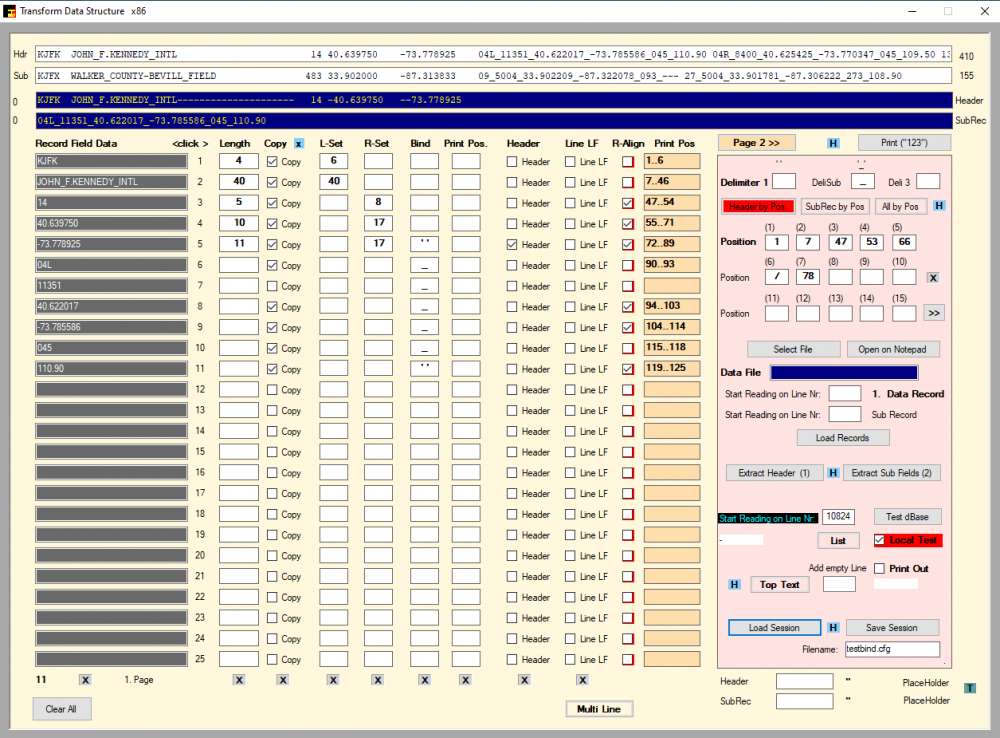
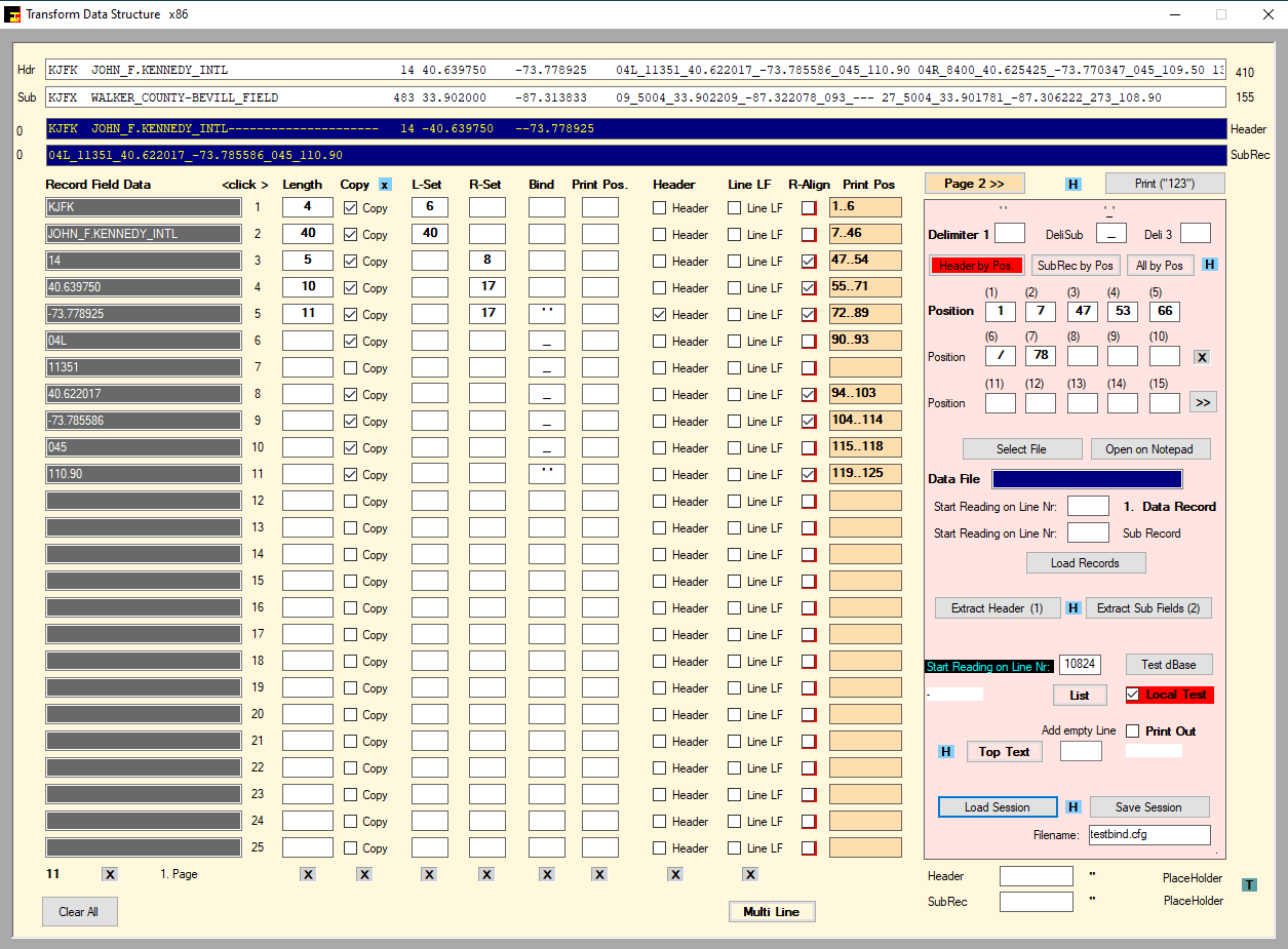
This program is reading any text database cvs ecc... dividing Headers single or multiple, SubRecords with different initial digits, extracting in any sequence.
The user must have a very good knowledge of the various structures of a dBase text. It's amazing how many variations there are. I wrote it several years ago to create my personal dbase. In fact the program name is: AiracStructure
Only 1 user, a german company is using it for extracting and translating Frequency dBases for the Radio Amateur world in different forms. To help i just need 1 complete Record and what should be the result for creating a configuration file. The program is Freeware. I'm a Radio Amateur.
An expert like you notes the presence of R-Set and R-Align which are 2 different things.
In this example we have a Header Record with all SubRecords in 1 Line only.
A delimiter "_" is used only for the Header in order to read the Apt names without the "_" digit.
While the following Runway subfields are read "by position". The space digit divides the SubRec Runways. This is a simple example..
-
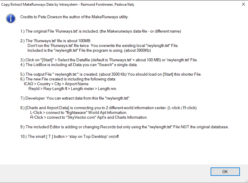
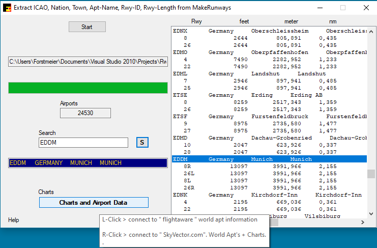
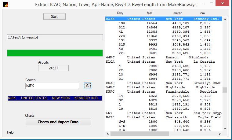
Years ago I wrote the program
"RwyLength"
This program extracts the fields from MakeRunway:
Icao, Nation, Town, Apt-Name, Rwy-ID, Rwy-Length.
Rwy Length is converted to:
feet, meter, nmThe program includes the original MakeRunway dBase file with 100MB and the extracted file with 4MB.
It is possible to load both files. Using the original file the conversion is immediate.
This means that a new MakeRunway.txt file can also be converted.I remember that I immediately noticed the extra "0" and my code recognizes it and does not consider it.
In order not to confuse, regardless of the use of other programs, my software that uses the dBase of RwyLength only uses the Rwy-Coordinates of a different dBase which includes Apt's coordinates and Runway coordinates.
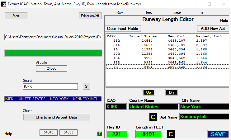
In Sept 2021 i added a Editor to create and edit Apt's and Runways.
In fact some users extract data from "Rwy-Length" and coordinates from a different dBase.
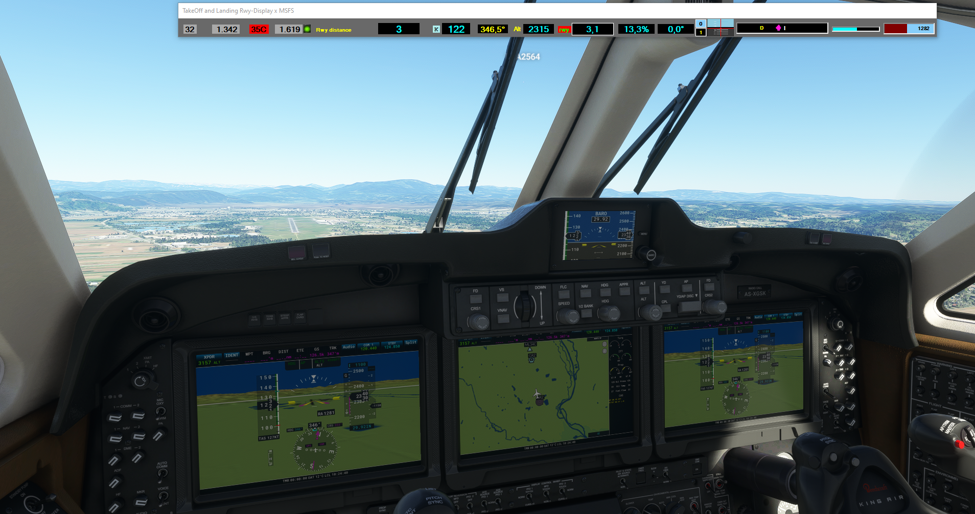
The AddAirports program is including the Apt's and Rwy-Data. This program is connected to the Simulator and the Rwy-coordinates are precise because you are placing the aircraft at the Lat / Lon position.
The Apt Lat / Lon and the Rwy Lat / Lon are different.Add Airports is including a Editor for deleting, creating and changing each Record and Field. A distance test is present.
ATIasHold is only working with internal real world Mathematic-Formulas based on Coordinates.
Credits to the work of Ed Williams and his Aviation Page: HereThese programs are included in the "ATIasHold" (Freeware) program
If interested, it is possible to download individual applications on request by email only.
Pls. refer to my Web-Page and indicate the program to download.The Radar image Takeoff and Landing graphic is only opening on Ground or Touch Down indicating the exact Aircraft Runway position.

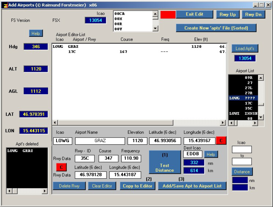


Raimund
http://www.intrasystem.it/ATIas/ATIasHold.html
.
-
Frustrated ? Maybe you are really right.
Pls. follow a forum discussion about it in MSFS. Read the full discussion.
FSX
https://steamcommunity.com/app/314160/discussions/15/1629663273598864558/?l=japanese
There are several other....
I'm using only own software.
http://www.intrasystem.it/ATIas/ATIasHold.html
Raimund
http://www.intrasystem.it/ATIas/ATIasHold.html
.
-

ATIasHold includes the "RwyLength" program.
RwyLength extracts 6 data from Pete Dowson's "MakeRunways".
Icao, Nation, Town, Apt-Name (the Header) and
Runway ID, Rwy-Lenght in feet as Sub-Records.
The File "rwylength.txt" is created and used by ATIasHold.
Contains length in feet, meters and nautic miles.Upon request, a Record Editor has been added to change data and add new Airports.
Intrasystem
Raimund
.
-
ATIasHold final update is ready for download. Uploaded 29/AGO/2021
Pls. read the extended ATIasHld.pdf File.
Intrasystem
.
-
ATIasHold is including now the MSFS Simulator.
ATIasHold ist 100% Freeware.Intrasystem
.
-
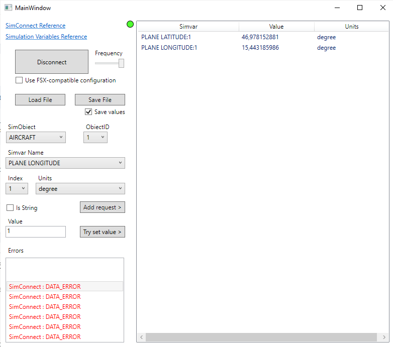
There is a interesting "Simvars.exe" in the MSFS SDK > Samples > SimvarWatcher > bin > x64 > Release.
Start the MSFS Simulator.
[ Connect ]
It can be a help and test for developers.
I'm adapting my Software "ATIasHold" for use with the MSFS. So far no problem.
Raimund
.
-
ATIasHold since 2011.
A lot has changed in the last few years. ATIasHold is now adapted to the development.
Version 1.7.0 update 08/2021 - Now freeware
ATIasHld.pdf Introduction:
http://www.intrasystem.it/ATIas/ATIasHld.pdf
http://www.intrasystem.it/ATIas/ATIasHold.html
Please read the download condition. Intrasystem does not allow a download without a request by e-mail.
(security + avoid Web-Scanning)
Intrasystem
Raimund Forstmeier - Padova / Italy
.
-
ATIasHold since 2011.
A lot has changed in the last few years. ATIasHold is now adapted to the development.
Version 1.7.0 update 08/2021 - Now freeware
http://www.intrasystem.it/ATIas/ATIasHold_Main_OpenFlp.png
ATIasHld.pdf Introduction:
http://www.intrasystem.it/ATIas/ATIasHld.pdf
http://www.intrasystem.it/ATIas/ATIasHold.html
Please read the download condition. Intrasystem does not allow a download without a request by e-mail.
(security + avoid Web-Scanning)
Intrasystem
Raimund Forstmeier - Padova / Italy
.
-
> Settings/Realism page. (Messages) <
i mean then 'Realism' configuration you find p.e. within the FSX configuration menu. I don't know if it is including the Door messages.
If you follow the Link above you can exclude it. Not easy but possible with a Hex-Editor or dll-debugger. Maybe you find someone near to you that can help you.
Always make a Backup of the original file.
Raimund
.
-
On 16/03/2017 at 0:18 PM, HILOK said:
hi pete, hello everybody,
let me start by saying that FSUIPC is just THE most useful addon for FSX/P3D EVER!
with that out of the way, is there any chance you could add an option to suppress the open / close door banner?
from what i understand the "language.dll" must be edited (can't be done simply in fsx.cfg). seems a bit too complicated -and risky- for the standard user, so a simple-click option within FSUIPC would be welcome, i guess : )
maybe there are even more banner messages hidden in that file, which we could get rid once and for all.
sorry, if this has been addressed earlier, couldn't find anything using the search function.
thanks and all the best,
HiLok
Settings/Realism page. (Messages)
Didn't Try it. Not sure if it is possible.
You should search with the word "disable ....."
Raimund
.
-
22 hours ago, Luke Kolin said:
Pete, I appreciate the integration work you've done with the PMDG 737, 747 and 777 aircraft. We can extract a lot of useful data from them via the custom offsets.
I'm running into a few cases where the SDK integration is turned on in the Options.ini file but I'm not getting data from the PMDG SDK. I check the "aircraft model" offset that comes from PMDG since that should never be zero if the SDK is passing data correctly to FSUIPC, but it appears to be.
I'm curious how the integration works on your end. Do you make the SimConnect calls no matter what and just copy over any data that comes over, or are you searching for specific AIR files or other triggers to pull the data?
Cheers!
Luke
Maybe it can be of help. My post is here and explaning in details how read and set data with the PMDG 737 + 777 using Simconnect and a transformed .h file x VB.net.
Raimund
.
-
You must copy the original "Runways.txt" file that is created when you run "MakeRunways" > "makerwys.exe" (by Pete Dowson) into your actual working Folder where RwyLength is installed.
(this Runways.txt file is about 100Mb)Install / unzip where you like. Create a separate Folder.
This program is extracting:
ICAO, country, City, Apt-name
..... Rwy-ID, length in ft, le in meter, le in nautic miles.Click on [ Start ]
(creating a new txt-file you can use and extract data in case you need this data for your own applications)
Later on, selecting the new created (shorter) File, the program start is faster.You could use this program (with your own application) p.e. for creating a precise Runway-Length graphic display.
(when the APL passed 70% of rwy-Le the graphic could change color or a sound is advicing you)
What you need is the position Lat/Lon where your Runway is starting.
If the Aircraft is ready for take-off you can calculate the precise Rwy-Distance left based on:
Lat/Lon Pos Start-Rwy - Distance to any next or destination lat/lon position - considering the RywLenght and your actual Apl-Position lat/lon.
Input a ICAO into the Search-Field > click [ S ]earch button > select the List-Item-Airport.
Input a ICAO into the Search-Field > direkt connection to Charts and Airport Information.The Charts [ Charts and Airport Data ] Button is connecting you directly to:
L-click >" flightaware" world airport information
R-click >" SkyVector" world aiports + Charts[ Help ]
x avoiding Web-Scanning:
User: Runway
Pwd: 12345Free Download here:
http://www.intrasystem.it/FSX/RwyLength/RwyLength.rar
Raimund
.
Credits to Pete Dowson the Author of MakeRunways.
.
-
2 hours ago, buick552 said:
Gentlemen, I need to ask this because I have FSX only on my computer, I dont have the chance to try with P3D or FS2004..
Now, I used this code..
Dim fsver As Offset(Of Integer) = New FSUIPC.Offset(Of Integer)(&H3308)
And I received -86114296 in turn. I again used the hex function and the result was FADE0008.
Mr Dowson, in your pdf guide, you declare that "FS version, as determined by FSUIPC: Currently only one of these:
1 = FS98
2 = FS2000
3 = CFS2
4 = CFS1
5 = reserved
6 = FS2002
7 = FS2004 ―A Century of Flight‖
8 = FSX
9 = ESP"Now that I found FADE0008, if I trim the first part which is FADE000, then the result would be 8, and I use FSX.
If I had had FS2004, the result would have been FADE0007 ?
Try this one:
Dim FsVersion As Offset(Of Short) = New FSUIPC.Offset(Of Short)(&H3308)
Dim iShort As Short = FsVersion.Value Select Case iShort Case 1 Me.txtFsVersion.Text = "FS98" Case 2 Me.txtFsVersion.Text = "FS2000" Case 3 Me.txtFsVersion.Text = "CFS2" Case 4 Me.txtFsVersion.Text = "CFS1" Case 5 Me.txtFsVersion.Text = "Fly!" Case 6 Me.txtFsVersion.Text = "FS2002" Case 7 Me.txtFsVersion.Text = "FS2004" Case 8 Me.txtFsVersion.Text = "FSX" Case Else Me.txtFsVersion.Text = "FS ?" End Select -
4 hours ago, dwhsmart said:
Hi Thomas
I am using FSUIPC Version 4.955c. The aircraft model is PMDG-777-300ER. The development environment is Visual Studio 2015(.net framework4.0 , VB.Net). The FSUIPCClient.dll that is used is V2.4.
About the Spoilers offsets, whether on the ground or in the air, 0BD0, 0BD4, 0BD8 these three are able to get to the value, only 0BCC can not get the value.
In addition to the GPS system, are there other offsets that can get information on approach status, route distance and estimated flight time?
Thanks again for your reply.
You can read and write offsets for the PMDG-777 with the Pmdg777 SDK.
When coding with VB.net you can include the translated SDK (x VB.net) for the Pmdg777. You read and set all those values.
You need the Microsoft.FlightSimulator.Simconnect.dll and the PMDG_777X_SDK.h > in your VB.net "Release" Folder.
Just read this Post >
By the way: you can use the FSX Simconnect.dll for reading and setting the Spoiler "Tick number" and the "Spoiler position value". There is no problem with using different sistems together.
The route distance "from" > "to" can be calculated in this way: (this is the real nautical mathe formula)
Dim LatitudeAircraft As Offset(Of Long) = New FSUIPC.Offset(Of Long)(&H560)  'Latitude
Dim LongitudeAircraft As Offset(Of Long) = New FSUIPC.Offset(Of Long)(&H568) 'Longitude

     Lat1 = LatitudeAircraft.value
     Lon1 = LongitudeAircraft.value

     lat1 = lat1 * 90 / (10001750D * 65536D * 65536D)
     lon1 = lon1 * 360 / (65536D * 65536D * 65536D * 65536D)

     'Dim d As Double
     'lat2, lon2 = destination coordinates that could be the runway center Start position
     d = distance(lat1, lon1, lat2, lon2, "N")  'distance between 2 Pos


    'Function calculate lat, lot between 2 points in distance
    Function distance(ByVal lat1, ByVal lon1, ByVal lat2, ByVal lon2, ByVal unit) As Double
        Dim theta, dist
        theta = lon1 - lon2
        dist = Math.Sin(deg2rad(lat1)) * Math.Sin(deg2rad(lat2)) + Math.Cos(deg2rad(lat1)) * Math.Cos(deg2rad(lat2)) * Math.Cos(deg2rad(theta))


        'Dim dist As Double
        'read distance result with 1 or 2 decimals    .ToString("f2")
        dist = acos(dist) ' used if theta in calculation is used

        dist = rad2deg(dist)
        distance = dist * 60 * 1.1515
        Select Case UCase(unit)
            Case "K"    'Kilometer
                distance = distance * 1.609344
            Case "N"    'Nautic miles
                distance = distance * 0.8684
        End Select

    End Function


    'convert decimal degreees to radians
    Function deg2rad(ByVal Deg)
        deg2rad = CDbl(Deg * pi / 180)
    End Function

    'convert radians to decimal degrees
    Function rad2deg(ByVal Rad)
        rad2deg = CDbl(Rad * 180 / pi)
    End Function


    'get arccos using the arctan function
    Function acos(ByVal rad)
        Dim pi As Double = 3.14159265358979
        acos = 0
        If Math.Abs(rad) <> 1 Then
            acos = pi / 2 - Math.Atan(rad / Math.Sqrt(1 - rad * rad))
        ElseIf rad = -1 Then
            acos = pi
        End If
    End Function

    Public Function Atan2(ByVal y As Double, ByVal x As Double) As Double
        Dim Pi As Double = 3.14159265358979

        If y > 0 Then
            If x >= y Then
                Atan2 = Math.Atan(y / x)
            ElseIf x <= -y Then
                Atan2 = Math.Atan(y / x) + Pi
            Else
                Atan2 = Pi / 2 - Math.Atan(x / y)
            End If
        Else
            If x >= -y Then
                Atan2 = Math.Atan(y / x)
            ElseIf x <= y Then
                Atan2 = Math.Atan(y / x) - Pi
            Else
                Atan2 = -Math.Atan(x / y) - Pi / 2
            End If
        End If

    End Function
Always specify when referring to a PMDG aircraft
You would need a similare calculation approach when using the pmdg / VB.net SDK.
Raimund
.
-
On 18/10/2016 at 10:13 AM, Delphi said:
Hi Paul,
currently I'm working on a RAAS system. The FSUIPC DLL Longitude/Latitude Helper Classes is a big help in the realization of the project. I wonder if it is possible to calculate the distance from a aircraft position and track to a runway FsLatLonQuadrilateral, based on Longitude/Latitude Helper Classes functions.
Thanks for your help!
Rüdiger
""" calculate the distance from a aircraft position and track to a runway """
What do you mean exactly ?
Just on Ground or also from Aircraft-Air position to any Rwy Center-Start-Position. Maybe i can help you. Given Lat/Lon it is easy to calculate.
Raimund
.
-
Hi Fred,
"At Landing" or "at/during Landing Approach". There is a difference.
You get the V/S data while approaching and Landing via FSUIPC as well as the ALT value and Speed. What you are looking for is your personal idea i don't think you will find a ready code for it. You need V/S, ALT and Speed values as well as the distance to the runway and the Rwy-ALT for a acceptable result to save.
The sequence of your Data within your DB is important.
Raimund
.
.png.c6085b8de9bc057b975f22ef1bb290b2.png)
.png.d6f6f26e6f53d074ebdea52698115c02.png)

Need help...
in Intrasystems Support Forum
Posted
My simple answer is, what about indicating which Simulator you are using.