

agutz
-
Posts
34 -
Joined
-
Last visited
Content Type
Profiles
Forums
Events
Gallery
Downloads
Posts posted by agutz
-
-
Thank you very much. It also works in P3Dv4.
Andreas
-
Why so secretive, Sabrefly?
Where is the post on that "other forum" where you found "a tiny exe that easily converts fxml to flt"?
Are you allowed to share?
Regards, Andreas
-
Hi David,
I'm glad to hear that most of your problems with FSC have been solved.
As for Vox: "How do you pre choose the right runway and
taxiway re wind direction at the planning stage to align with the VOX ATC
directions. Last night I had a different runway and therefore taxiway."
That's not the way Vox is used. Start your weather program (if you have any), then FSX, activate Vox, listen to ATIS and let Vox's clearance do the choosing for you.
If you have any problems with Vox there is a forum at AVSIM.
Cheers, Andreas
-
Hi David,
thanks for the screenies.
The first and second show the path where FSX reads .PLN files: "c:\users\david\my documents\flight simulator x files".
The sixth shows where FSC saves .PLN files for use by FSX: "c:\users\david butt\documents\flight simulator files".
That's a different path and a different folder! No wonder FSX can't find fpls created by FSC.
I hope this solves this part of your problems.
Regards
Andreas
-
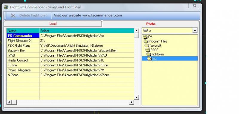
Hi David,
I think before everything else you have to make sure that your fpl created by FSC 9.2 is saved to the right paths.
It looks like your fpl created by FSC 9.2 is not correctly saved (or, worse, it's not a valid fpl), otherwise you would see it in the FSX "departure and arrival windows in the planner" if you load the fpl into FSX.
The saving paths are chosen in FSC "Save/Load Flight Plan - Paths". The first 3 items are FS Commander, Flight Simulator X, FSX Flight Plans. I want to see what paths you have put under "Folder" (consult the manual!). Make a screenshot, if possible.
To check if you have it right: Save a fpl in FSC, start FSX and in the opening window (with any girating plane) chose Flghtplanner - Load - filename.PLN. Now you should see dept/arr airports. If you don't see them there is something wrong and it's of no use to go on further. This has to be solved first.
Please advise!
Regards,
Andreas
Attached: My FSC paths
-
David,
I'm afraid I don't understand your problems.
You have to be a lot more specific about what you mean by "it does not register and fails to appear in the overall main flight plan which I am compiling in SFX . It just does not appear when asked to load in the destination windows unlike all other plans."
What are you trying to "compile in FSX"?
Who is asking you to "load" what into which "destination window"?
Sorry, but I'm totally confused about what you are trying to do!
Regards,
Andreas
-
Dave,
first you have to overcome your runtime error when saving the fp.
FSC has to know at least these locations for saving fps (put these into FSC Save/Load Flight Plan, Paths):
FS Commander: I have c:\program files\aerosoft\fsc9\flightplan\fsc
Flight Simulator X: your root folder of FSX
FSX Flight plans: ...\yourname\documents\flight simulator x files
Now both FSC and FSX can read the fp.
To get Vox going you have to (1) load the fp (a .PLN file you created with FSC) and (2) SAVE the situation once your plane is at the right place (this will create a .FLT file). I am not aware that this is a "problem" with Vox that has to be fixed, it's SOP.
As for SID/STARs: Strictly speaking these are not part of the fp. The IFR plan you file begins with the first waypoint and ends with the last. SID/STARs will be assigned to you by ATC depending on weather/runway in use/traffic etc. PMDG e.g. will remove any SID/STARs from your fp when you load a company route into their FMC.
Regards,
Andreas
-
Hi David,
1. VoxATC will give you SID/STARs at the appropriate time. You don't have to choose any beforhand.
2. and 3. Vox ATC and FC9 use Navigraph NavData (http://www.navigraph.com/ ). Important: the cycle has to be the same for both (right now it's 1304). FC9 and Vox have different formats. What formats to use and where to put them is in their manuals.
4. Do you mean FC9 (not FS9)? I posted at AVSIM about how to load an FP into FSX and start Vox: http://forum.avsim.net/topic/389273-flightplan-and-voxatc/
Regards
Andreas
-
Paul, I just realised you have FSUIPC on your system. I think for the Autosave function to work you need a registered version (latest is 4.864).
Andreas
-
Hi Paul,
Pete Dowson's FSUIPC (http://secure.simmarket.com/pete-dowson-fsuipc4.phtml) saves your flight situations at specified intervals. I keep 10 situations in 3 min intervals. If anything goes wrong you can then reload one of these flights and continue.
Andreas
-
When approach tells you to expect vectors to 4L its too early to ask for an IAP. This has to be done after you have got the first vector. One of RC's special features.
If RC still vectors you around it means they haven't got your request. Otherwise, as FS1TR said, you won't hear anything from RC until final.
I don't know about the difference between the flightplans FSC/RC and FSC/FSX. You can look at the plans with Notepad.
RC uses the flightplan set in the RC Options panel (.FLT/.WX Path) which should be set to "NetworkDrive:\your name\documents\flight simulator x files".
BTW: update FSUIPC, its now at 486.
Are your sceneries updated with the latest makerwys 4614?
Andreas
-
Hi Marbasan,
you don't have to download new Navdata when you install new sceneries.
Just running the FSC Database Manager will do it.
Regards, Andreas
-
Hi Volker,
yes, we have been looking ate the same places.
The only thing not open to regulations by (national) authorities is the elevation MSL.
As I said, I wouldn't mind having these MEF in FSCommander replacing MSA because these are "hard" figures.
So for the LOWI section you would see MEF 12.0. Adding 2000ft gives you FL140 which is safe enough.
Regards, Andreas
-
 1
1
-
-
Hi Volker,
I searched the internet for any usable definition of MSA (Minimum Sector Altitude) or GASA (Geographic area safe altitude) but did not find anything really useful.
There are definitions for "Minimum obstacle clearance altitude (MOCA)", "Minimum enroute altitude (MEA)". Both vary for different terrain and other conditions. The only thing well defined seems to be the terrain itself!
Sectional charts, like the one I was using in the present discussion, "show the ground with considerable accuracy, both for terrain levels and for man-made objects. The charts are marked with grids, and at the center of each grid square a number shows the elevation (MSL) of the highest obstacle within that grid." (Wikipedia)
That is MEF (Maximum Elevation Figure). Actually, I wouldn't mind having these figures in FSCommander, because "it is up to the pilot to select a cruising altitude which will provide the required clearance above those obstacles." Most commonly an altitude of 2000ft above any obstacle is mentioned.
Regards, Andreas
-
Hi Volker,
I would not hurry to change MSA units from "miles" to feet because they are in feet already. There is nothing fundamentally wrong with FSC's MSA. reading1871 just read numbers from different places.
"North of LOWI" is the quadrant EDDM is in and that is given as 6.3 in FSC.
For the quadrant of LOWI I see 14.8 in FSC (13.4 in AivlaSoft's EFB). 12.0 is the MEF (Maximum Elevation Figure) according to Switzerland 2253-B. Innsbruck is surrounded by mountains between 9700ft and 11400ft, so an MSA between FL134 and FL148 seems reasonable.
7800ft would be rather deadly.
Cheers, Andreas
-
Hi Xaver,
I have a suggestion: isg readable flight plans do not neccessarily have to be saved to the ...\isg\flightplans folder. You can make isg to read default fsx flight plans by adding the line "FlightPlansFolder=[location of your FSX flight plans]" to the file isg.cfg.
Regards, Andreas
-
Hi Sascha,
I think he wants to know if the information in the GPS window can be read by JAWS.
Regards, Andreas
-
Captain Sim's B707 is a historical aircraft. At that time GPS was not available, INS or VOR to VOR navigation was used. However you can use a flightplan made by FSC9. Load the plan as you would with any other a/c and activate the AP in NAV mode. It will follow the flightplan.
-
Hi,
can this fix also be used by Aerosoft customers?
As far as I can see it's not listed on their support.
Andreas
-
Update on my particular problem: During the last flights the GPS window remained visible. I hope it stays that way.
Regards, Andreas
-
Hi Sascha,
I don't give focus to another app because there is no other app running on the client PC.
When I click on the GPS window (after having resized FSC) it will not stay on top of the main FSC window but immediately disappear.
I use exactly the sam config as with FSC 8.6. where this never occurred.
Regards
Andreas
-
OK, so I see the GPS window but only for about 5 minutes. Then it disappears to the background although I have unchecked "Map always on Top". FSC9 is running full screen on the client PC.
Andreas
-
2.) Why are you using 2 different folders for that, it would be much easier to handle ONE directory with TWO filetypes for FSX and FSC. In this case it would be easy possible to use a directory structure as with version FSC8.
When you are using (as I do) FSX/FSC in a server/client configuration the 2 directories are even on 2 computers.
Andreas
-
I had the same problem, you solved it.
Thank you very much
Andreas
RC4 can't resume a saved flight in P3Dv3?
in FSUIPC Support Pete Dowson Modules
Posted
Something might have changed.
Almost two years ago I downloaded it from "Useful additional programs".
It contaimed a file fxmltoflt.exe which I'm still using.