

fltsimguy
-
Posts
40 -
Joined
-
Last visited
Content Type
Profiles
Forums
Events
Gallery
Downloads
Posts posted by fltsimguy
-
-
OK ...I remember a comment about it but chose to ignore it, i guess at my peril eh, I will revisit. Thanks.
-
Its been a while since I have been visiting the forum. I purchased a new computer and had huge difficulty setting it up but seem to have most issues sorted out now.
But each time get into something I find issues. I also turfed the old CRT and have a new flat screen monitor and there may be issues related to this as well.
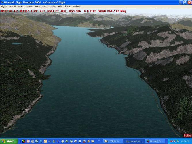
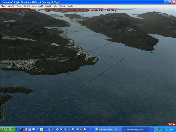
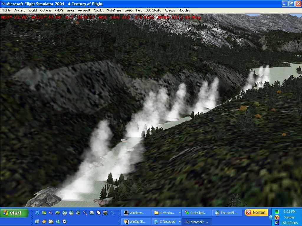
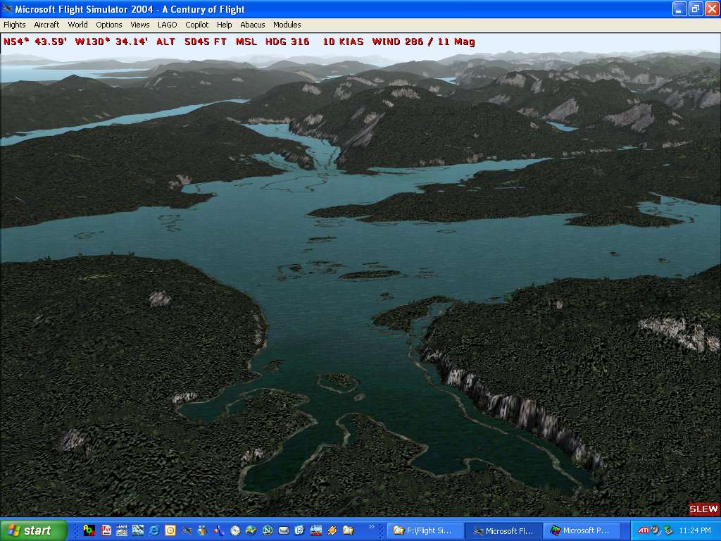
ONE: I loaded up Tongass Fjords after installing the Stikine River Enhancement #1. But things just didn't seem right, first I had to suffer through reregistering my FSE 2004 by Lago.
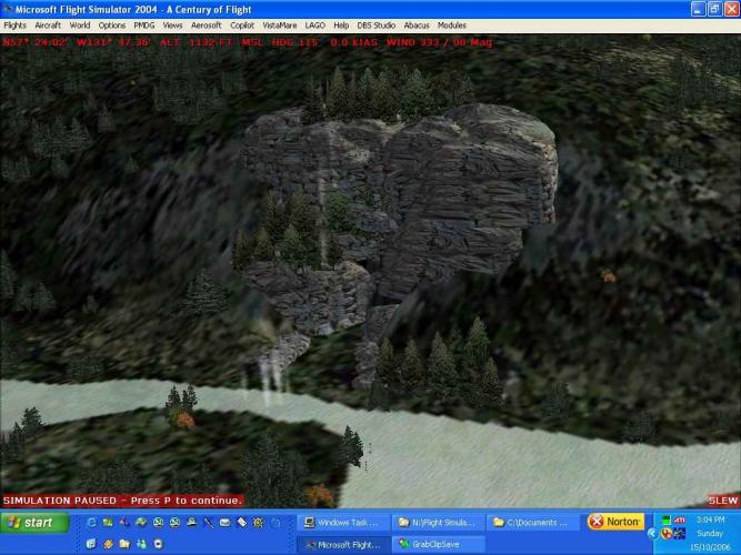
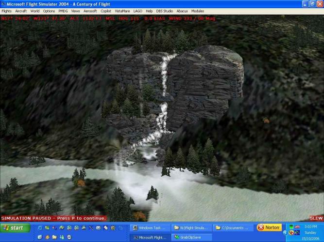
I have attached some screen shots of the KCHUTE area. When I have the LAGO editor turned on I get a whole bunch of the expected effects of waterfalls, fog mist etc. But, when I shut of the editor, it dissappears.
Does anyone know why?
TWO: The adjacent waterfalls, rapids appear to be in the air, this doesn't seem correct, I haven't tested extensively, would this be related to these settings? I like to run my TMV very high so am wondering if this might be the issue?
[TERRAIN]
TERRAIN_ERROR_FACTOR=100.000000
TERRAIN_MIN_DEM_AREA=10.000000
TERRAIN_MAX_DEM_AREA=100.000000
TERRAIN_MAX_VERTEX_LEVEL=21
TERRAIN_TEXTURE_SIZE_EXP=8
TERRAIN_AUTOGEN_DENSITY=5
TERRAIN_USE_GRADIENT_MAP=1
TERRAIN_EXTENDED_TEXTURES=1
TERRAIN_DEFAULT_RADIUS=3.5 //was 5
TERRAIN_EXTENDED_RADIUS=4 //was 9.5
TERRAIN_EXTENDED_LEVELS=232 //was 4
Any ideas?

-
Hi Holger from PEI. Its late at night here and I just find I have to keep up with my addiction to FS.
Your screenshots are alarming/shocking to say the least. Taking into consideration the product being in development and your cautiions, I have to say I am somewhat surprised at the "lack" of effort to bring these areas in north american to an extreme high standard given that the information/data required to do so is readily available.
I guess I will have to keep my fs2004 HD space for sometime yet.
-
I have some 120 EZS Libraries installed. To keep it all straight as to which ones I have, I created a special set of duplicate folders, numbered all libraries, linked to authors, maintained a written record of all the website file names, made up photo libraries of the objects...a massive undertaking. And use LOM by Scuffy Duck (Jon Masterson)
This posting is only meant to encourage a discussion on a useful alternative.
Some time back I posted the idea that I take all the libraries and make up a "Mother of All" EZ Scenery Library sets putting all libraries into one large package or maybe a couple of volumes and upload these to the websites or origin for redistribution to users to avoid them having to search and install the myraid of libraries and their updates and their missing texture files etc. I have seen my freeware work reposted elsewhere, and quite frankly I could care less, I uploaded it for others benefit and use.
I did not get a good reception about repackaging others work, I respect others opinions and concerns (even though everyones work is freeware and no files would be changed in any way, and all original documentation would be maintained). I still say it is the best approach to users avoiding missing objects, missing textures and they can install in a very short timeframe instead of days of downloading, messing about.
If you aren't an EZS owner why the heck would you want to sit there for hours and search for and install all the required files. Just take a look at the Shit Creek posting chain and you will see what happens when your missing objects.
cheers, that offer is still open....but I have no appetite for contacting all the library original authors to get permissions that in itself would be a huge task.
I would welcome any other who might want to undertake such an assignment, or further would encourage those who have compiled EZScenery Libraries to repackage all their work into a convenient ONE file upload. This would be of great help to those who like to keep upgrading their scenery with all these wonderful freeware projects.[/b]
-
I am curious about the animated canoes.
I have LAGO and EZ Scenery. I have Ron Jeffers canoes sets for both products. I have done animated canoes in my Bowron Lake Scenery but never released it because I was having so much difficulty with overloading my computer using FSE from LAGO.
Are you using EZScenery for your animated canoes? In FSE its easy to do a track and let the canoe follow it, how are you doing the EZ Scenery version? As I want to do similar work in other areas?
-
Your right about the mesh, of course I should have known that.
I spent the entire evening sorting through my files, the problem was missing textures near Sandspit.
A lengthly process of trial and error, some custom scenery that I made.
Sorry to take up forum space in the end I figured it out.
Sometimes though sharing your problem can help others who experience a similar thing and then they recall reading about it somewhere, and then they have some clue about what might be wrong.
cheers
-
Using LWMViewer I found that the area is covered by the series
**912130
I noticed that this is likely an Ultimate Terrain Canada issue. Or at least I think, I had inadvertantly deactivated HP912130.BGL, so I reactivated it...and presto I have my proper shorelines back, however....
Now I getting the dreaded CTD's. Any attempt at flying over this area is resulting in a complete freeze up of FS9 and my screen goes black, I then have to reboot to get going again.
So, now I have no clue whatsoever.
I guess I will stoll over to UT forums and see whats cooking over there, however, if anyone knows of a CTD issue in the QCI area please let me know.
I am running with MF, TF, Holgers freeware sceneries (every last one of them)and FS Genesis Cordiller 38m mesh.
Is it possible the I might have another mesh that overlaps somehow that would conflict, like these below which I am running??
United States - West Coast 38m Mesh - Justin Tyme, or
United States - West Coast 19m Mesh - Raimondo Taburet
United States - Alaska 38.2m Mesh - Raimondo Taburet
-
Not a problem, I have tons of beautiful coastal areas to fly. But I would like to get my Queen Charlottes back.
Kinda looks like a scenery incompatability issue to me or a shoreline or waterbodies file that is duplicated.
I will try LWM Viewer tonight to see if I can locate the cells involved and try some searchs to find some suspect files.
I am heading away on a holiday myself on the weekend so golfing will take over from flying then anyway.
cheers.
-
I had the same double shorelines as many other folks and with the great help in this forum managed to track down the culprits and presto my Misty and Tongass were one (shoreline) that is.
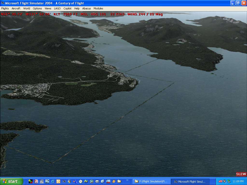
So tonight I take a flight from Tongass Area, pass over Misty heading to QCI, the Queen Charlotte Islands (QCI), I hadn't been there in a long time.
Now I don't know if any of the scenery files associated with Misty or Tongass affect the QCI's but thought I might get some help here.
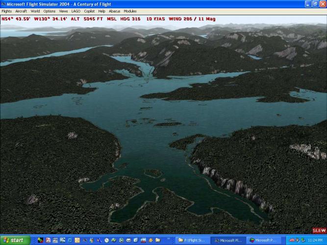
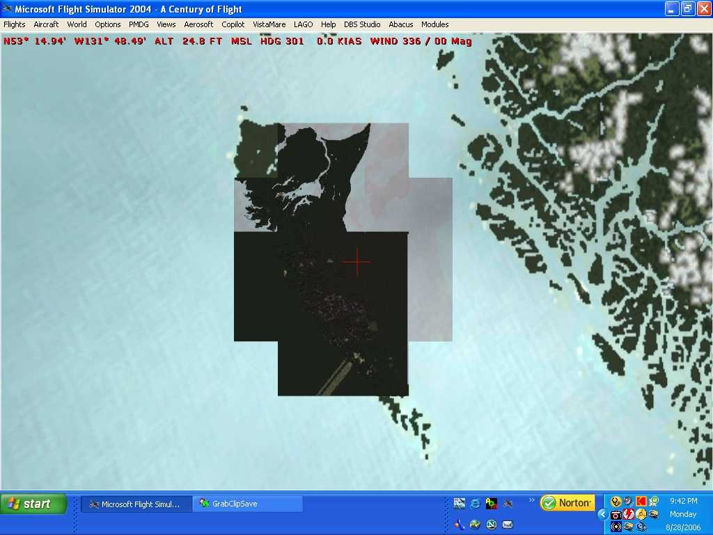
Here is a satelite view of my plane sitting at Sandspit, which is supposed to be right on the water, but I have a massive cell of land covering the entire southern Island.
I am wondering what in the world would cause this? Any help would be greatly appreciated, as it is now I can almost walk from the QCI's to the mainland, no need for a ferry or plane.

-
sorry, had an Internet outage this morning (excellent timing; thanks, Murphy!)
The price you pay for living in the wonderful outback of BC! Can't have it both ways eh! At least you have a great view, beautiful scenery and peace and quiet.
We totally understand.
-
Funny, I would have thought that 38m mesh and UT shorelines was the standard by which every thing would be judged. Why the heck is Microsoft putting out a demo with such substandard mesh?
Nice shots Holger! Looks like we will have to port over many of our addons to make FS10 look like it should.
After FS204 came out I remember hanging on to FS2002 for a year and a bit before finally turfing it in favour of FS2004 because I had build such a rebust FS2002 system and FS2004 did not have the same quality in places I liked to fly.
-
Rest assured that Holger almost has a patch ready. It's in the final testing stages and has shown major improvements. :)
BTW it's FPS ( Frames Per Second ). 8)
Gosh you can sure tell I am on holidays for three weeks, what was I thinking. Too much sun, golf, swimming, paddling and hiking I guess.
cheers.
-
Ah the old FSP discussion again.
You folks haven't lived until you hit 6 fsp at Sitka . My system fluctuates considerably at Sitka, its great for using helicopters but forget coming in with a jet. My 3 year old machine is starting to chug a little with all this great new detailed scenery. Fortunately, I spend most of my time exploring the wilds of the Pacific Northwest in float planes, then I manage to get 25-35 fsp.
cheers
-
While I realize this takes server space. I do like the one stop shopping over at Misty Moorings for the scenery addons that folks have made.
-
FAAAANTASTIC!! Too funny :lol: :lol: He might be refreshing change to what we have now.
Say, Jon did you put in the windmill of fantasy gardens, I never looked for that?
I did however, hover over playland and watched the roller coaster, the ferris wheel and death drop of whatever its called. Nice touch.
-
From my end, you will need to sit tight for a few days as I have family coming for the holidays, and board games, laughing and joking around become the priority.
I did some more work on Mt Rainier (MRNP) tonight just to get back into it after a month away frmo the project to work on DVD's of home photos and movies. I will continue with work on (MRNP) but I could take a break and go back to that roads piece on southern VI. I can package and upload, some folks might not be too concerned if there is not a perfect match, just so as they have the roads. Look for something uploaded after xmas weekend.
cheers
-
Hi. I did a roads fix for the excluded roads on southern vancouver island once it was pointed out to me what the issue was sometime back. This included actually fixing to divided highway that heads right into downtown Victoria from Elk Lake and then out up island to Duncan. The problem I encounted was road textures. I do not like the final product. Jon and Holger explained to me the issue and I for the life of me could not get the textures to match up. I ended up with dark grey defaults and this looked poor hooking up with UT road. And also traffic lights moving along the road, but it looked weird when the lights just stopped when my road ended. I haven't gone back to this work in sometime now.
Anyway, I gave up on this project, to continue work on my Mt Rainier project. Now that I have some holidays I can continue working on some of this stuff. I have no idea where you folks find the time to do all this? I have tons more details to get done on this work.
Anyway, if I get some solution on the road textures to match I will let you know. And, Jon I will advise you on anything that would help with fixing the lost roads issue.
-
SUCCESS!!!!! :D :D
I am so excited to have my Misty Fjords fixed I think I will stay up all night and fly around, na....my employer would not like that.
I went back to square one, double checked library order, installations etc. I then applied the NEW PATCH V4 FOR MISTY FJORDS. Somehow, I have no idea how, I ended up NOT removing all the required files from my UT folders. Patch 4 worked like a charm picking up all the offending shoreline files.
So, I highly recommend getting patch v4 and applying the update patch.
Thanks for your encouragement. :lol: :lol:
-
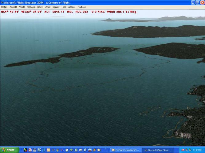
I'm giong to review everything I can tonight and again see what I can find. However, take a look at my screenshots again. You will see in the last photo for instance, at the bottom left very accrurate shorelines that are the same texture as the shorelines on the right side of the inlet. And the shoreline textures appear to be HS's custom shorelines, I will check that out right now.
And take a look at the islands in the other shots, the shorelines that show are very accurate not default straight and boring. Its like my land hasn't filled up some of the space between the shorlines and land.
So if HS's and UT's detailed shorelines are showing what does that mean?
I don't think those ARE the default shorelines?
-
Please stick with me on this one, I am at work and can't get into this until tonight.
I did try removing the enhanced shorelines and also deactivating the scenery completely and of course it removed the double shorelines but then I ended up with default shorelines, which are not anywhere near that of the enhanced scenery.
Francois, I saw that HS was off to Europe, thanks, probably a well deserved holiday. I was believing that I still had default shorlines active somehow and now matter how in depth my search I couldn't find those culpit files.
Let me do some more on this tonight, but please don't leave me stranded on this, its just exhausting me trying to find out the problem.
-
I can't believe it! I have the dreaded double shorelines in my Misty Fjords scenery.
I have read the sticky and other posts on the issue and applied all the checks I can think of.
I have done a file by file search for the 13 files that are supposed to be removed or renamed to deactivate. That's done and OK, I have no double sets of files.
Here is my scenery library layout for in the order listed in my scenery library, ie with the lowest # at the top and highest below, just as in the example screenshot provided in the sticky.
mesh FS Gensis Cordillera Canada 38.3m
mesh Raimondo Taburet - Alaska 38.2m
UT USA City Landclass
FS Genesis Landclass of USA
UT Terrain - USA
UT Terrain - Canada/Alaska
US Alaska Misty Fjords - Landscape
US Alaska Misty Fjords - Scenery
I have tried moving all these layers around up and down, inside and out (ok just kidding).
I have searched folders till I am blue in the face, must have rebooted my FS9 - 50 times testing combinations.
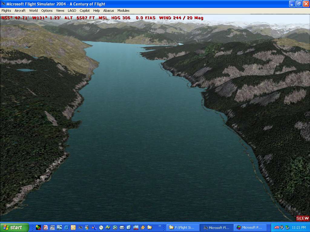
I still have double lines. But sort of weird. I have attached screenshots. I have square pattern to the shorelines near Ketchican. I have a pattern where the double shorelines show on the west side of islands and inlets but not the east side in most cases in open water situations, however for lakes the double shorelines are all around the lakes (on larges lakes, smaller lakes are just fine).
Here are screenshots of my experience. I am totally frustrated at this problem. I am reluctant to uninstall Misty and UT etc because of all the patches and process needed, and would likely screw it up again.
PLEASE, ANY THOUGHTS ON HOW TO 'REPAIR' THIS SITUATION.
-
OK sorry....I was looking in completely the wrong place.
The incompatible file was from Bill Freeborn's bc_xp.zip. I had unchecked it in my scenery library to remove it during installion but because of another copy in my addon scenery it was still being read. I deleted the entire set of files and everything is hunky dory.
cheers
-
I was flying up the valley checking out bases. I found that my AF2_CAY7 Mission SPB was under the Fraser River. I mean totally, not sign of it. Yet my FS Navigator shows its existance.
I did a scan for the file and the only file that showed up was:
AF2_CAY7 Mission SPB.bgl under the following folder. Also my FS Navigator showed the same file and location when I highlighted it with my cursor.
F:\Flight Simulation\Flight Simulator 9\FSAddon\VancouverPlus_1\VancouverPlus_1_scenery\Scenery
Is this just my problem? Could I somehow have some portion of Curt Jardey's BC Bases7.zip left over in my file structure. I couldn't find any part of it when I looked.
-
Yes I have read the manual from cover to cover, which might be a rare thing and noted the photos profiles etc. and many contributions of others on the team.
By no means would I ever want to take away from the great contribution and aspects of this scenery that were made by the many others of the "team". Congrats to all!


Comments on FPS FSX FIBER
in FSPS Support Forum (LEGACY)
Posted
Nelson, there are plenty of help opportunities for OMMs. One of the best summaries available is over at AVSIM. They have a CTD guide in pdf format that lists the common reasons and what you might do about them. I highly recommend it. This may at least solve some of your issues.
You also seem to have a pretty good PC so shouldn't have much of any issue running FSX in general.
I have a friend who has a slightly less of a PC than you do, that runs FSX very well but he recently tried the demo and did see a small improvement, so perhaps focus on the OMMs first then give it a go again.
Bryan