-
Posts
1,203 -
Joined
-
Last visited
Content Type
Profiles
Forums
Events
Gallery
Downloads
Everything posted by GHD
-
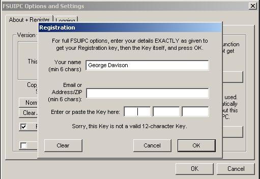
Having tried to copy/paste the registration key given by SimMarket, I get the following: Help :cry: George
-
Just a quick postscript to say that although I haven't yet received my registration key, my existing (C++, FSUIPC3, FS9) compiled programs work fine through FSUIPC4 to FSX. Hopefully with the key, GPSOut will interface with Fugawi Maps as in FS9. Thank again, George
-
Thanks Pete, downloaded successfully. George
-
Pete, I have just purched a registration for FSUIPC4 from SimMarket but the link to http://www.schiratti.com/dowson appears to be broken. Is 'Install_FSUIPC4_4011_revised.zip' mentioned in 'Other Downloads and Updates' now the preferred installer? George
-
Thanks for the update Pete. It doesn't sound too promising for the weather features. George
-
Hi Pete, Now that the retail version of FSX is available (got mine in the UK today), can you say when FSUIPC 4 will be made available. I desperately need to use the visibility settings. George
-
All vectors are 3D. For 2D, set the third component to zero which is quite adequate for small distances. If the block of airspace is delimited by two heights, you simply check as above then check max/min height. Unless the heights are wildly different, then you need to use spherical projection. George
-

FSUIPC....an general question !!
GHD replied to Paschu's topic in FSUIPC Support Pete Dowson Modules
Paschu, In FS, from the initial page, select "Settings/General" then uncheck the box "Pause on task switch". This will allow FS to continue whilst your window has the focus. George -
Remember your sig: THINK TWICE !!! :roll:
-
Isn't it obvious which one is wrong :wink: George
-

Can you control AI Traffic AND ATC?
GHD replied to vstokes's topic in FSUIPC Support Pete Dowson Modules
I agree, what I mean is that using either Map/coordinates for the user aircraft, or TVB (which slews the user aircraft to the AI position) causes the scenery anomaly shown above. George -

Can you control AI Traffic AND ATC?
GHD replied to vstokes's topic in FSUIPC Support Pete Dowson Modules
You need to consider carefully whether to use the slew feature with AI. I am having great difficulty with FS Nav and Traffic View Board observing AI helicopters landing on oil rigs. Each rig has an associated flatten at sea level and the afcad is at the pad height. If I slew to the rig using either the FS Map option or either of the two aforementioned programs, the sea and hence the rig is raised to the pad height. Here is a view from TVB: and here from a nearby rig: George Thanks to ImageShack for Free Image Hosting -
I think the sequence is E 1 then E 2 etc. George
-
Thanks Pete, yes, I am George Davison (initials GHD). Unfortunately I had never heard of "MakeItVersionFS2002" and in fact never received his log file. Thank you for your extremely prompt response, George
-
Thanks Pete, I have asked him to provide the log and key files. However, the program does include a free key in the version information. Regards, George
-
I have created a freeware application which reads 0x3308 to check that the value is 7 (FS2004). One of the users running a registered FSUIPC V3.44 does not get past this check. He is running the German version of FS2004 9.1, could this be the problem? There have been over 800 downloads of the program with only one person reporting this fault. Any help would be gratefully received, George
-

Any relief from the inflated Euro for US customers?
GHD replied to neil0311's topic in FSUIPC Support Pete Dowson Modules
For years, we in Britain have had to suffer the unrealistic 1$=1£ on all computer related products. It is only now becoming reasonable. George -
Thanks Pete, I just ignored the FSVersion reply and collected the position and heading which worked fine, all I need to do now is to use a Hot-key to determine when I should retrieve the values. I'm still reading the comprehensive documentation so I'm sure I will figure it out very soon. Thanks for a great interface. George
-
I am just starting to understand the FSUIPC interface from Visual C++ and have compiled the example UIPCHello. This compiles ok, however on running it with FS9 running, I get: Sim is:--------------(null) FSUIPC Version:--3.411 FSClock:------------11:09:36 What does FSUIPC_FS_Version return for FS 2004 ? What I hope to do is just extract the current aircraft position and heading so that I can create XML code to define a runway and parking from the current position and heading. George
-
The only reference I have seen to MSIti64.exe is on a German forum: http://www.trojaner-board.de Search with Google and translate. George
-
Can I say that GPSOut works well with Fugawi UK Digital Maps by using the free ComEmulDrv serial port bridge driver from http://www.mixw.net This allows the map to show the current position in FS. All thanks to Pete 8) George

