pilotjohn
-
Posts
407 -
Joined
-
Last visited
-
Days Won
3
Content Type
Profiles
Forums
Events
Gallery
Downloads
Everything posted by pilotjohn
-
The two letters at the end of a wind group provide turbulence and shear, so instead of 27060KT&A3000NG I put NI (no turbulence, instantaneous shear). I believe some of this is actually missing in your struct-to-METAR code as occasionally I've seen things like A3000G or A3000N etc. I believe two letters might be required. Did you also notice that variance information was being sent after each wind group in that whacky KTTN METAR from the theme? You only send one, correct, even if I include variance information in other layers? Is this because it doesn't work?
-
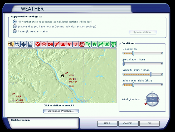
All I did was start FSX, load my default flight with KTTN set, and select the weather theme. As the flight got progressively along, the layers got more and more confusing. That's the one I grabbed after about 5-10 minutes of slewing and checking the GUI, when I finally launched WeatherSet2. Another 5-10 minutes later it was looking nastier (dynamics?). Initially they looked a little cleaner but I didn't have KTTN which is why I asked for it specifically. I included the image to make sure we're talking about the same thing when talking about a station (something that has an ATIS and shows in the weather GUI). Well, I did some additional testing. I set the shear level to instantenous. This stopped interpolating and only provided the required wind when the altitude provided in &A is passed. This would indicate a "base" as you suggested. I'm trying to figure out the need for a surface depth then. It seems using a simple &D1 (&D0 doesn't work) for the surface layer is probably the correct approach for me as then all wind is interpolated to whatever wind aloft is at the airport elevation without having a "fixed" layer. Thanks for sticking with my investigation.
-
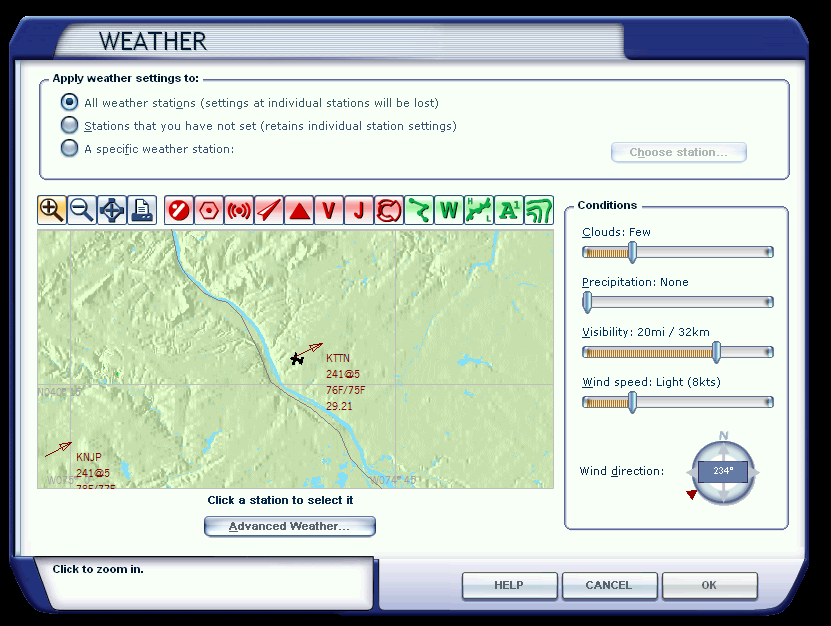
Odd... I'm getting different results. Using FSX Acceleration KTTN is definitely a station and has an ATIS (screenshot attached). 1. I put the plane at KTTN. 2. I loaded Developing Storms theme 3. I launched WeatherSet2 and looked the request return for KTTN The METAR from KTTN is: 295919 Weather Received (type 3 request, AtStation): "KTTN&A64 151850Z 22805K T&D1057LM 227V229 22805KT&A1000LM 227V229 23206KT&A1000LG 231V234 22805KT&A1064L M 227V229 23206KT&A1121LG 231V233 23306KT&A1124LG 231V234 23306KT&A1128LG 231V23 4 23407KT&A1188LG 233V235 23407KT&A1192LG 233V235 25015G26KT&A2000LG 249V250 250 15G26KT&A2000LG 249V250 24416G28KT&A2064LG 244V245 24416G28KT&A2128LG 244V245 32 KM&B-257&D30736 2CU048&CU004FMVN000N 8CI301&CI000FNVN000L 2CI390&CI000FMVN000N 2 4/24 24/24&A0 23/23&A1300 23/23&A1300 23/23&A1364 23/23&A1428 23/23&A1492 23/23& A1556 22/22&A1620 22/22&A1684 22/22&A1748 21/21&A1812 21/21&A1876 Q0989 @@@ 35 2 3 228 5 | 35 23 232 6 | 37 23 228 5 | 39 23 232 6 | 39 23 233 6 | 39 23 233 6 | 41 23 234 7 | 41 23 234 7 | 68 21 250 15 | 68 21 250 15 | 70 21 244 16 | 72 21 2 44 16 | " Let's assume they're layer tops as depicted in the FSX GUI. Then... At 4000 feet there's a 7KT layer, and at 6600 feet, a 15KT layer, with the highest layer of 16KT at about 6800 feet. 4. I slewed to 5500 feet, and there's 11KT wind there (about right for interpolation between 4000/7 and 6600/15) 5. I slewed to 7500 feet, and there's 15KT wind there (about right for above any interpolation layer) These wind speeds are too close together for clear testing (screenshots attached) which is why I tested with pretty obvious layers and speeds. It's odd that winds aloft would behave differently than all the other weather parameters (visibility etc.) which use upper altitude to delineate a layer. In my case and testing winds aloft behave similar to visibility layers.


-
No, I don't think it's an FSX bug. If you write X and read back and get X than FSX is not altering anything, thus there's no bug (only if it behaves differently than written, but it doesn't, you write X as the layer top, you read back X, and FSX is using that as the layer top). It's just that the &A should be the layer top, and that's how FSX interprets it (per "option B" in the documentation). If you were writing X and getting X+Y or getting X but FSX behaving like X+Y than I would concur that it's an FSX bug and you're "fixing" it. But that's not the case here. Checked at KTTN (same METAR but KTTN instead of GLOB). Same result (writing, reading, behavior, GUI all agree as layer top). See log below: 176874 NW_CLEAR weather command received 176874 NWI weather clear actioned 176874 External weather discarded 176936 Weather Mode now = Theme 176936 Weather Mode now = Custom 177872 Setting Metar: "KTTN 000000Z 36010KT&D1000NG 27060KT&A3000NG 15/10&A0" 178059 Weather Read request (At Aircrft) to area 4: Lat=40.27, Lon=-74.81, Alt=66.8, Req=2 178059 Weather Received (type 4 request, Interpolated): "????&A0 151734Z 36010KT&D1000NG 100KM&B-1500&D2021 CLR 14/09 Q1013 " 178059 WX Received in 0 mSecs, WX request type 4, Lat=40.2730, Lon=-74.8084,Alt=66.8m 181226 Weather Read request (Nr Station) to area 5: Lat=40.27, Lon=-74.81, Alt=0.0, Req=1 181226 Weather Received (type 5 request, Nearest): "KTTN&A64 000000Z 36010KT&D1000NG 27060KT&A3000NG 100KM&B-1564&D2021 CLR 15/10 Q1013 @@@ 101 15 270 60 | " Aside from the "feature" in global mode of ignoring winds aloft, in custom mode all signs point to the fact that &A should be the layer top, not base: in writing and reading the METAR, in behavior, and in FSX weather GUI. How about "NWI_SETCORRECTLY" instead? :)
-
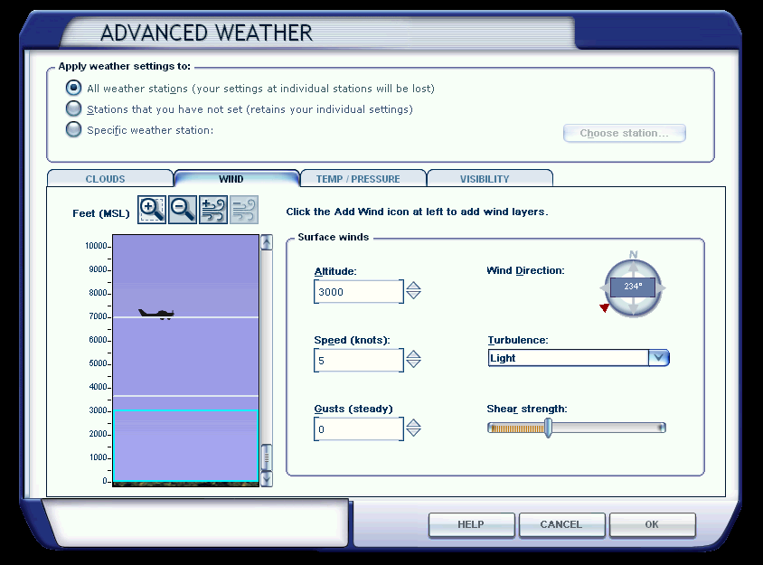
Pete, In this non-global custom mode, my original "bug" report stands. The winds aloft altitude after the &A should be the upper altitude, not the upper altitude less surface wind depth. I just tested this with the two following METARs and the described results which show that &A should have the layer top, not base. GLOB 000000Z 36010KT&D1000NG 27060KT&A3000NG 15/10&A0 At the surface the wind was shown as 10 KTS. Slewed to 5000 feet the wind read-out was 24 KTS (which is about correct for interpolation using 10000-3300=6700, 60-10=50, 5000-3300=1700, 1700/6700*50=13, 10+13=23). GLOB 000000Z 36010KT&D1000NG 27060KT&A1100NG 15/10&A0 At the surface the wind was shown as 10 KTS. Slewed to 5000 feet the wind read-out was 60 KTS (no interpolation since above the layer top), and at 3500 feet the wind read-out was 37 KTS (which again is correct for interpolation, 3700-3300=400, 60-10=50, 3500-3300=200, 200/400*50=25, 10+25=35). Can you fix this please? Regards, John
-
Ok. I just tested, and not setting global mode (setting dynamics to 0, clearing weather, then setting GLOB METAR) works for winds aloft. I now have to re-test all the other stuff I generate (temp/visibilty/clouds).
-
Well winds aloft in global mode definitely don't work, no matter what I do. How can I use the FSUIPC facilities to set the weather mode to "Custom" so that individual stations can be set? There's GLOBAL mode, and I can clear weather which reverts to "Theme" mode (according to logs). But it seems "custom" needs to be used if I want to set all stations and use "GLOB" to propagate to unset stations.
-
If global turns out not to work... Would you be able to add facilities for evaluating the nearest or adding "virtual" stations? As it is I can't determine what the nearby stations are if I have to use station-based weather settings since I don't see any facility for that except <??> which sets weather for THE nearest station. Perhaps if a lat/long is given, FSUIPC should create a virtual station at that location using the ID given in the ICAO field and then set the provided weather for it. That way I could create a grid of stations. If I don't enter global mode and set GLOB weather will it set all stations to that weather? What is that mode called? Theme?
-
Thanks... I'll keep poking. Both write and read look good in terms of winds aloft, they show up correctly in the FSX weather GUI, and WeatherSet2, but I'm not getting the results in flight. I used the B offset to write some METARs directly (now that it works - thanks again for fixing that BTW) but it seems to have no affect either (wrote GLOB 000000Z 36010KT&D1000NG 27050KT&A3000NG 15/10&A0) which again looks good in FSX GUI but doesn't get simulated. If I view it in the GUI and click "OK" it starts to work. The same thing happens if I use WeatherSet2 to add a layer. It shows up but doesn't appear to be simulated. You said doing this on a per-station basis works?
-
Yes, definitely in global mode (FSUIPC logs show this, weather cleared) and clouds(at least what works)/visibility/temperature are set correctly. The logs above are the METAR sent and received, correct? Or is there additional logging available?
-
Yep... for the sample above I was getting 5-6 KTS at 18000 feet during the slew read-out. I'll finish up my weather generator as is, and see how it feels with the limitations FSX imposes.
-
The read-back shows the same as that which was written (e.g. base altitude not the top of the layer, is this correct?). I'll take your word for this since slewing through layers seems to not show the correct wind, although everything in WeatherSet2 and FSX GUI, and read-backs show the correct settings. Only the surface wind read-out seems correct, regardless of the number of layers I create and where in the layer I am trying to slew/un-slew to check wind. 1853479 >NewSet: Surface wind: to alt=10000ft AMSL, dir=215T, vel=2.00, gust= 3.0, turb=0, shear=0, var=4.8 1853479 >NewSet: Wind layer 1: to alt=20000ft AMSL, dir=236T, vel=26.0, gust= 1.0, turb=1, shear=1, var=2.9 1853479 >NewSet: Wind layer 2: to alt=30000ft AMSL, dir=257T, vel=63.0, gust= 0.0, turb=0, shear=1, var=7.8 1853479 >NewSet: Cloud[0]: type=8, from 6170ft to 25410ft (+/- 0ft), cover=2, turb=1, topshape=0 1853479 >NewSet: Precip=0, base=0ft, rate=0, icing=0 1853479 >NewSet: Cloud[1]: type=9, from 10690ft to 16710ft (+/- 0ft), cover=2 , turb=1, topshape=0 1853479 >NewSet: Precip=0, base=0ft, rate=0, icing=0 1853479 >NewSet: **** End of New Weather details for ICAO=GLOB 1853479 Setting Weather: "GLOB 141503Z 21502G05KT&D3048NG 213V217 23626G27KT&A 3048OM 25763KT&A6096NM 34KM&B-1&D1 34KM&B1&D1015 42KM&B1016&D1016 49KM&B2032&D10 16 57KM&B3048&D1016 65KM&B4064&D1016 73KM&B5080&D1016 80KM&B6096&D1016 88KM&B711 2&D1016 96KM&B8128&D1016 2ST062&ST192FOVN000N 2CU107&CU060FOVN000N 16/08&A0 09/M 06&A3048 M16/M24&A6096 M40/M53&A9144 Q1029 " 1859875 WX Error: timed out, WX request type 5, Lat=41.0669, Lon=-74.5561, Alt =0.0m 1874882 Weather Read request (At Aircrft) to area 4: Lat=40.36, Lon=-74.56, Al t=115.3, Req=2 1874882 Weather Read request (Nr Station) to area 5: Lat=40.36, Lon=-73.63, Al t=0.0, Req=1 1874882 Weather Received (type 4 request, Interpolated): "GLOB&A0 141503Z 2150 2G05KT&D3048NG 213V217 23626G27KT&A3048LM 25763KT&A6096NM 34KM&B-1&D1 34KM&B1&D1 015 42KM&B1016&D1016 49KM&B2032&D1016 57KM&B3048&D1016 64KM&B4064&D1016 73KM&B50 80&D1016 80KM&B6096&D1016 88KM&B7112&D1016 96KM&B8128&D1016 2ST062&ST019FLVN000N 2CU107&CU006FLVN000N 16/08 09/-6&A3048 -16/-24&A6096 -40/-53&A9144 Q1029 @@@ 10 0 9 236 26 | 200 -16 257 63 | " 1874882 WX Received in 0 mSecs, WX request type 4, Lat=40.3567, Lon=-74.5567, Alt=115.3m
-
Pete, I think there's a bug in how you translate the NWI winds aloft structure to the extended METAR syntax. See below: 1233328 >NewSet: Surface wind: to alt=3330ft AMSL, dir=42T, vel=8.00, gust=1. 0, turb=0, shear=1, var=4.2 1233328 >NewSet: Wind layer 1: to alt=6670ft AMSL, dir=43T, vel=15.0, gust=1. 0, turb=1, shear=1, var=2.8 1233328 >NewSet: Wind layer 2: to alt=10000ft AMSL, dir=44T, vel=23.0, gust=1 .0, turb=2, shear=0, var=5.1 1233328 >NewSet: Wind layer 3: to alt=13330ft AMSL, dir=45T, vel=30.0, gust=0 .0, turb=1, shear=0, var=4.8 1233328 >NewSet: Wind layer 4: to alt=16670ft AMSL, dir=47T, vel=36.0, gust=0 .0, turb=1, shear=1, var=0.6 1233328 >NewSet: Wind layer 5: to alt=20000ft AMSL, dir=48T, vel=41.0, gust=0 .0, turb=1, shear=1, var=3.4 1233328 >NewSet: Wind layer 6: to alt=23330ft AMSL, dir=49T, vel=41.0, gust=0 .0, turb=1, shear=1, var=0.7 1233328 >NewSet: Wind layer 7: to alt=26670ft AMSL, dir=50T, vel=49.0, gust=0 .0, turb=0, shear=0, var=4.1 1233328 >NewSet: Wind layer 8: to alt=30000ft AMSL, dir=52T, vel=54.0, gust=0 .0, turb=2, shear=1, var=8.7 1233328 >NewSet: Cloud[0]: type=9, from 3420ft to 5574ft (+/- 0ft), cover=1, turb=2, topshape=0 1233328 >NewSet: Precip=0, base=0ft, rate=0, icing=0 1233328 >NewSet: Cloud[1]: type=9, from 6780ft to 10476ft (+/- 0ft), cover=1, turb=2, topshape=0 1233328 >NewSet: Precip=0, base=0ft, rate=0, icing=0 1233328 >NewSet: Cloud[2]: type=9, from 12960ft to 17700ft (+/- 0ft), cover=1 , turb=2, topshape=0 1233328 >NewSet: Precip=0, base=0ft, rate=0, icing=0 1233328 >NewSet: **** End of New Weather details for ICAO=GLOB 1233328 Setting Weather: "GLOB 141541Z 04208G09KT&D1016NM 039V044 04315G16KT&A 1016OM 04423G24KT&A2032LG 04530KT&A3048OG 04736KT&A4064OM 04841KT&A5080OM 04941K T&A6096OM 05049KT&A7112NG 05254KT&A8128LM 32KM&B-1&D1 32KM&B1&D1015 38KM&B1016&D 1016 43KM&B2032&D1016 48KM&B3048&D1016 54KM&B4064&D1016 59KM&B5080&D1016 64KM&B6 096&D1016 70KM&B7112&D1016 75KM&B8128&D1016 1CU034&CU022FLVN000N 1CU068&CU037FLV N000N 1CU130&CU047FLVN000N 25/16&A0 05/M09&A3048 M17/M26&A6096 M19/M32&A9144 Q10 25 " The sections after the surface wind should contain the actual UpperAlt value for the winds aloft, but it looks like you're subtracting the surface wind depth from each (the first one should be 2032, and last one should be 9144, but they are all less by the depth of the surface layer). "The altitude of a WINDS ALOFT section specifies the top of the layer in which the given wind data is to apply. The bottom of the layer will be determined by the top of any lower layer, either another WINDS ALOFT entry, or the SURFACE WINDS entry." This is visible in FSX weather interface, as the first aloft layer is nearly on top of the surface layer. Can you fix this? Also, I'm not sure if the SimConnect METAR documentation is in the correct order, but if it is, the surface wind variation should come after the winds aloft section, not after the surface winds. (http://msdn.microsof...y/cc526983.aspx) Regards, John
-
This is a Lua script that provides all sorts of failure scenarios. It can be auto-loaded at start so you don't have to set up failures every time. It can be configured for many different behaviors and probabilities. I have it running all the time, so I always have to be vigilant to make sure I didn't forget things. Flying the simulator can degrade your real-life skills because there are no consequences for being lax. This can alleviate some of those tendencies. You can also assign buttons/keys to show the current failures (if you can't figure out what went wrong) and to reset them. Rename to .lua and follow instructions at the top. RandomFailure.txt
-
Throttle Manager to Allow Axis Forward/Reverse Toggle
pilotjohn replied to pilotjohn's topic in User Contributions
If you turn on "Filter" on the throttle axis, you won't have the hang in REV problem. You can also increase the threshold where the auto-forward toggles. -
Loggin of [Auto] Startup
pilotjohn replied to pilotjohn's topic in FSUIPC Support Pete Dowson Modules
Now, I'm motivated... maybe a free copy of WideFS so I can run BlackBox on a client machine. -
Loggin of [Auto] Startup
pilotjohn replied to pilotjohn's topic in FSUIPC Support Pete Dowson Modules
Do I get a prize when I report the 10th bug? :) -
Loggin of [Auto] Startup
pilotjohn replied to pilotjohn's topic in FSUIPC Support Pete Dowson Modules
Very odd... key presses work for the Lua, but [Auto] does not. I changed script ordering, still nothing. In an act of desperation, I renamed it from SetFuel to FuelManager, and it worked. Can I not use "Set" in the filename for [Auto] - as shown above? -
Loggin of [Auto] Startup
pilotjohn replied to pilotjohn's topic in FSUIPC Support Pete Dowson Modules
I'll try that... 4.745. can I do an Auto on any aircraft change (I understand the reload limitation) like Auto.*? Regardless, I'm just running a simple script to reload fuel tanks to 50+/-5% and for some reason that doesn't seem to happen when I first load a flight even though the Auto section is: [Auto] 1=Lua ConstantFailure 2=Lua ThrottleManager 3=Lua SetFuel -
Is there some logging option I can enable to log [Auto] script parsing/starting? I have some [Auto] scripts that work. I added a new one and it doesn't seem to load on aircraft switches. It runs if I assign it to a key press, added ipc.log() to it, but won't start on [Auto].
-
Yes, that's how I was using it for my reverse throttles, and they were working correctly. Here are the results in -16k..16k, showing the value for those extremes at 0x3330: 1. assigned in FSUIPC direct to calibration, but uncalibrated 0..16384 2. ditto calibrated, not NRZ 6144..16384 3. ditto calibrated, NRZ (but i think this is the case you are using?) 8192..16384 4. assigned in FSUIPC to FS control "AXIS THROTTLE1 SET", but uncalibrated 0..16384 5. ditto , calibrated, not NRZ 6144..16384 6. ditto , calibrated, NRZ 8192..16384 I unchecked Exclude/nSet (otherwise it would nothing) 7. assigned in FSUIPC to FS control "THROTTLE1 SET", but uncalibrated 0..16384 8. ditto , calibrated, not NRZ 6144..16384 9. ditto , calibrated, NRZ 8192..16384 10. assigned in FS, uncalibrated 0..16384 11. ditto , calibrated, not NRZ 6144..16384 12. ditto , calibrated, NRZ 8192..16384 Looks like all the calibrated ones are incorrect. And, as I said before, the Joystick Calbiration GUI "OUT" value shows the correct value, not the incorrect one written to 0x3330.
-
I'm not sure why these were wrong before, they made sense before as they matched up with what the GUI was showing for out, and what you would expect the correlation to be between the raw joystick input and potential output to the simulator. On a joystick with a raw range of -16384 to 16384, direct to calibration and NRZ, it would set this value to 0 when the joystick was -16384, and to 16384 when the joystick was 16384. Now it's setting this value to 8192 when the joystick is is -16384 even though the GUI output is showing the correct value of 0. Mapping -16..16k to 0..16k with NRZ seems like the right move (that seems like "post calibration" to me), but that's not what it's doing anymore.
-
The METAR now updates correctly, thanks! But something broke in this version or somewhere between what I was running last. My throttle updates are incorrect. FSUIPC shows 0 being output at idle, but 0x3330 is updated with 8192 instead of 0 (direct to calibration, NRZ, filtering or not). This happens in both 4.743 and 4.744, but not the original install of 4.70 and certainly not what I was running last, which was 4.731.
-
Updated to 4.743, but the behavior is the same.
-
I turned on IPC write logging: ipc.writeSTR(0xB000, "GLOB 011907Z 00000KT&D609NG 100KM&B-1500&D6072 8ST010&ST500FNVN000N 4CU020&CU010FNVN000N 15/05&A0 Q1013") 12860317 WRITElua B000, 104 bytes: 47 4C 4F 42 20 30 31 31 39 30 37 5A 20 30 30 30 GLOB 011907Z 000 12860317 30 30 4B 54 26 44 36 30 39 4E 47 20 31 30 30 4B 00KT&D609NG 100K 12860317 4D 26 42 2D 31 35 30 30 26 44 36 30 37 32 20 38 M&B-1500&D6072 8 12860317 53 54 30 31 30 26 53 54 35 30 30 46 4E 56 4E 30 ST010&ST500FNVN0 12860317 30 30 4E 20 34 43 55 30 32 30 26 43 55 30 31 30 00N 4CU020&CU010 12860317 46 4E 56 4E 30 30 30 4E 20 31 35 2F 30 35 26 41 FNVN000N 15/05&A 12860317 30 20 51 31 30 31 33 00 0 Q1013. 12860317 Setting Metar: "" It logs blank regardless of what I try to write.