Graham Pollitt
-
Posts
148 -
Joined
-
Last visited
Content Type
Profiles
Forums
Events
Gallery
Downloads
Everything posted by Graham Pollitt
-
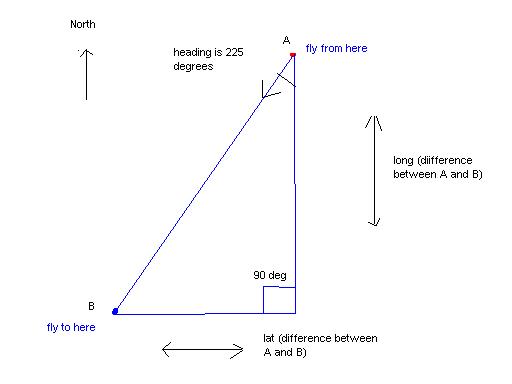
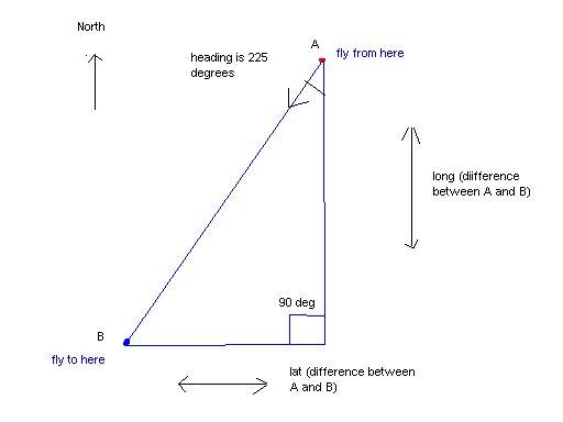
What is the best way to check that waypoints lat/long are being flown towards I though it could be something like this : take the difference of lat/long between the 2 waypoints 'draw' a triangle like the on the diagram 'track' we are on the hyp of the triangle by measuring the angle ie in this case it would be 45deg 'redraw' the triangle and check that the angle of 45deg has not varied more than a couple of degrees My concern with this is Im not sure I am going about it the correct way. For the plane to be heading towards the new waypoint both sides of the triangle opp and adj must decrease in size at the same time and the angle of the hyp must stay the same otherwise we are not on track. Has anyone looked at this problem before and got a better solution? thanks Graham
-
Glideslope and Localizer Needles
Graham Pollitt replied to hastim's topic in FSUIPC Support Pete Dowson Modules
Is there a certain amount per degree? ie the range for Glide slope is -127 to +127 with 0 being centred. How many of those units would be needed for 10degrees below? and are these 10degree steps linear? thanks -
get the specific aircraft type ?
Graham Pollitt replied to andflight2's topic in FSUIPC Support Pete Dowson Modules
So you can see what is happening the end quote " doesnt get read only with the Flight1 Cessna 172. The text read from the combobox also has "" either side. I suppose I could delimit the string to remove the "" but thought there may be an obvious fix I will see what Paul thinks in case it the dll thanks again Graham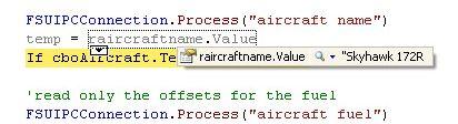
-
get the specific aircraft type ?
Graham Pollitt replied to andflight2's topic in FSUIPC Support Pete Dowson Modules
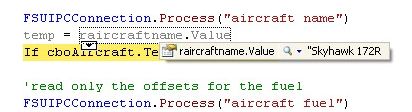
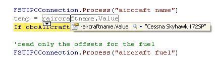
thanks for suggestions I am using VB.net 2005 SP1 with Pauls (phenty) vb.net dll within FS2004 The results you requested are: ********* FSUIPC, Version 3.75 by Pete Dowson ********* Running on Windows Version 5.1 Build 2600 Service Pack 2 Verifying Certificate for "J:\Program Files\Microsoft Games\Flight Simulator 9\MODULES\FSUIPC.dll" now ... SUCCESS! Signature verifies okay! Running inside FS2004 (FS9.1 CONTROLS.DLL, FS9.1 WEATHER.DLL) User Name="Graham Pollitt" User Addr="gjpollitt@yahoo.co.uk" FSUIPC Key is provided WIDEFS not user registered, or expired Module base=61000000 ClassOptions: UIPCMAIN=FF7F, FS98MAIN=FF7F, FS2KMAIN=FF5E WeatherOptions(Orig)=400CB78F[400CB78F] InitDelay: 0 seconds WeatherReadInterval=4 LogOptions=00000001 DebugStatus=15 1750 System time = 11:37:19 1750 J:\Program Files\Microsoft Games\Flight Simulator 9\ 1750 System time = 11:37:19, FS2004 time = 12:00:00 (00:00Z) 2578 FLIGHTS\OTHER\FLTSIM.flt 2594 AIRCRAFT\c172\Cessna172SP.air 2828 Aircraft="Cessna Skyhawk 172SP" 6875 J:\Documents and Settings\Graham\My Documents\Flight Simulator Files\UI generated flight.flt 7312 Monitor IPC:3D00 (AsciiZ) = [20]"Cessna Skyhawk 172SP" 8266 Advanced Weather Interface Enabled 22797 Traffic File #14 = "scenery\world\scenery\traffic030528" 33484 WeatherOptions set, now 400CB78F (timer=0) 52594 AIRCRAFT\Douglas_DC3\Douglas_DC3.air 52859 Aircraft="Douglas DC-3 Paint2" 55422 Monitor IPC:3D00 (AsciiZ) = [19]"Douglas DC-3 Paint2" 64812 AIRCRAFT\F1_Cessna_172\F1_Cessna_172.air 65062 Aircraft="Skyhawk 172R" 68359 Monitor IPC:3D00 (AsciiZ) = [12]"Skyhawk 172R" "Skyhawk 172R" appears ok here so it may be something to do with the way it is read within Pauls dll. Basically my code is this (though not listed like this in my app): Dim temp as String Dim raircraftname As Offset(Of String) = New FSUIPC.Offset(Of String)("aircraft name", &H3D00, 256) 'aircraft name FSUIPCConnection.Process("aircraft name") temp = raircraftname.Value If cboAircraft.Text <> temp Then Exit Sub this is to check the aircraft selected with my app matches the one loaded within FS2004. As mentioned I get the result of "Skyhawk 172R and not "Skyhawk 172R". I will drop Paul a msg and see if it could be with vb.net dll thanks again Graham -
get the specific aircraft type ?
Graham Pollitt replied to andflight2's topic in FSUIPC Support Pete Dowson Modules
Offset 256? I cant find any reference to that offset in the docs I am using the below at offset 3D00 Dim raircraftname As Offset(Of String) = New FSUIPC.Offset(Of String)("aircraft name", &H3D00, 256) 'aircraft name With default cessna 172 I read the whole aircraft name including "" surrounding the name With Flight1 cessna 172 I read all the name apart from the last " quote In the aircraft.cfg for the default the name is title=Cessna Skyhawk 172SP and for flight1 it is title = Skyhawk 172R. If I copy and paste the title from flight1 to default it gives me the same result. Any idea why this is please? All other aircraft names I have tried read "aircraft name" with the quotes. thanks -
About Information ATC, Ground flags
Graham Pollitt replied to Chrisoft-Dev's topic in FSUIPC Support Pete Dowson Modules
thanks a lot Mr D :D -
FSUIPC Client DLL for .NET - Version 2.0
Graham Pollitt replied to Paul Henty's topic in FSUIPC Client DLL for .NET
OK I think I need some help now :? As I mention on an earlier post it is fairly straightforward to obtain the 4 lat/long for each corner of the runway when it is at 0degrees (straightup). What I have been doing this morning is drawing the rectangle at 0degree position to obtain the 4 lat/long corners then thought it would be a case of rotating the BR, TL and TR corners x amount of degrees ie if the runway is 340 degree heading then I would need to offset those 3 corners to 340 degrees leaving the bottom left corner as is due to this being a rotation point. I know the middle position point at the bottom of the runway so I divide the width by 2 and add/subtract this to the middle position. I also know the point in the middle of the runway so I subtract the bottom point from the middle, double it and add it to the bottom to give me the length. I can then get my 4 lat/long corner points for the rectangle. BUT I now have a similar problem to my original one a few weeks ago with rotating these points x amount of degrees. I dont know how to convert ft into lat/long format so I am unable to properly find the width etc Any ideas please? Am I looking at this in the correct way? thanks -
FSUIPC Client DLL for .NET - Version 2.0
Graham Pollitt replied to Paul Henty's topic in FSUIPC Client DLL for .NET
Right I've found the width! I was looking at the very end of the line at stated in the readme, which in most cases is 0. It is sandwiched in the middle of the line. KSEA,0341,47.437584,-122.311058,429,340.300,9550,111.70,150,19.700,47.450684,-122.311058,0 Regarding the updated code I will try it myself over the next few hours and if I get stuck I will be sure to let you know Paul :D Best regards and thanks Graham -
FSUIPC Client DLL for .NET - Version 2.0
Graham Pollitt replied to Paul Henty's topic in FSUIPC Client DLL for .NET
I was using AFCAD to manually get the 4 corners of the runway and entering this info into an 'airport.dat' file. My app was working fine although I only had 6 airports in the list so far. Upon discovering MakeRwys.exe I thought it would be able to read all the info that I needed but it seems to lack on some points(unless I am not using it correctly!) Is there any way to read the width of a runway from any of the scenery bgl files? Using MakeRwys.exe I can obtain the centreline lat/long and the length of the runway. What I cant appear to do is to expand the centreline x degrees to the left and right to form a rectangle over the runway as I dont know the width. -
About Information ATC, Ground flags
Graham Pollitt replied to Chrisoft-Dev's topic in FSUIPC Support Pete Dowson Modules
Can somebody please tell me what the field headings are for the new R4.CSV produced from the latest MakeRwys.exe. I think its something like ICAO, Degreeheadingofrunway, Lat, Long (are these of the left corner of that particular runway heading?), ? , ?, RunwayLength, ILS freq, ? , ? , Lat , Long (of opposite left corner of runway?), ?, runway open/closed. What do the BDG stand for after the freqs? I've searched for info on this forum but I cant seem to locate anything regarding this. Thanks Graham EDIT Ive worked out the following icao, runway ie 0161 16L, lat/long of centreline at bottom of runway heading, airport elevation, runway heading/ .?, runway length, ils freq/backcourse/dme/glideslope, runway width, ?, lat/long of centre of runway/line, ? anyone please help with the 2 ? -
FSUIPC Client DLL for .NET - Version 2.0
Graham Pollitt replied to Paul Henty's topic in FSUIPC Client DLL for .NET
fantastic, just what I needed, works fine now thanks Paul :) -
FSUIPC Client DLL for .NET - Version 2.0
Graham Pollitt replied to Paul Henty's topic in FSUIPC Client DLL for .NET
My program can now check if a plane is on/off a runway KSEA works perfect as the runway is more or less straight up However, when trying to add KBFI I discovered a fatal flaw in my coding. I never thought that not all runways are that straightforward eg KBFI runway runs at 310degrees, which is -50degrees offset from north. Basically in my code I get the lat/long of my plane and check it against the 'box' of the runway. KSEA is fine as it is more or less a perfect rectangle at true north. Here is my code for checking I am on runway. (bl is bottom left, tr is top right etc) 'are we on ground and within the left side limits of the runway, left and right If onground = 1 And latitude > departurerunwaybllat And longitude > departurerunwaybllong And latitude < departurerunwaytllat And longitude > departurerunwaytllong Then 'are we within the right limits of the runway, left and right If latitude < departurerunwaytrlat And longitude < departurerunwaytrlong And latitude > departurerunwaybrlat And longitude < departurerunwaybrlong Then 'plane is on runway etc This works perfect for a 'straight-upwards box'. How can I rotate this 'box' 50 degrees to the left so I can check the lat/long of KBFI? Many thanks Graham -
FSUIPC Client DLL for .NET - Version 2.0
Graham Pollitt replied to Paul Henty's topic in FSUIPC Client DLL for .NET
I appreciate your detailed reply Paul. Thankyou I am coding a flight monitor to check I am flying the aircraft using correct procedures at each stage of flight. What I am trying to achieve is to detect whether the aircraft is on the runway, taxiway etc and then checking the appropriate lights, flaps etc are on/set. You make a good point of not converting the lat/long and I think that I will follow that. I am going to get the lat/long values from the airport charts and make a table so I can check the aircraft pos against it and know where I am. The charts are in dec,min,sec format so is there a quick fire way of converting this back into decimal format as read via your offsets? thanks again for your support Graham -
FSUIPC Client DLL for .NET - Version 2.0
Graham Pollitt replied to Paul Henty's topic in FSUIPC Client DLL for .NET
Hi I can read the lat and longitude as for example 47.xxxxxx and -122.xxxxxx degrees. Showing the co-ordinates in FS displays N47*26.75 W122*18.26. Does anyone know the code for converting the decimal degrees into degrees, minutes and seconds in VB.net? I am trying to code an app to 'read' where the plane is ie on a taxiway, parking or runway many thanks Graham -
PMDG 747 key stroke assignment
Graham Pollitt replied to psouthan's topic in FSUIPC Support Pete Dowson Modules
Hi guys What I do for the Level-D 767 and PMDG 747 is map the keys using the PMDG or Level-D key assignment menu eg Autothrottle on/off mapped to CTRL-Q In the sim CTRL-Q will then turn the autothrottle on/off If you need to map it to a button or joystick axis then then go into FSUIPC and map that key config to a button or axis on the controllers Only slight problem with all these addons is you find controls conflicting with each other so I recommend deleting all the pre-defined keys and remap only those that you will use. Works everytime for me! Regards Graham -
PMDG 737TNG Offsets
Graham Pollitt replied to Raafie75's topic in FSUIPC Support Pete Dowson Modules
No, they're just too busy. I got an answer from the guy I deal with, who is always very helpful. They are planning on providing a proper SDK for programming their cockpits, and it sounds like it's being worked on already, but they won't give timescales yet (I don't blame them, really. It's always a mistake). Whether this is what I want to interface to or not remains to be seen. At the very least you'd be able to use a keyboard interface, programmed for buttons via the FSUIPC Buttons page. I am hoping for more, but we'll have to wait and see. Pete Did this SDK from PMDG ever get released? I havent heard of anything from them Graham -
Just a polite enquiry to see if you have completed the docs yet :) Thought Id ask in case you have emailed me already and I havent received email again ! Thanks Graham
-
Hi Jon No I havent unfortunately, I wasnt sure if you had recieved mine. If you can send again please that would be much appreciated thanks Graham
-
I'd like a copy of this dll please, if that is at all possible thanks Graham
-
Checking VOR and radial headings
Graham Pollitt replied to Graham Pollitt's topic in FSUIPC Support Pete Dowson Modules
Thanks a lot for the effort in producing the update Im sure your efforts will be appreciated by more than just myself! Regards Graham -
Checking VOR and radial headings
Graham Pollitt replied to Graham Pollitt's topic in FSUIPC Support Pete Dowson Modules
[quote name="Pete Dowson Your VOR 'TEST' is not relevant of course' date=' it is the aircraft position which is relevant. [/quote] I know, my question originally was to find out the course outbound but I added another VOR and made it inbound. Dont know why ! -
Checking VOR and radial headings
Graham Pollitt replied to Graham Pollitt's topic in FSUIPC Support Pete Dowson Modules
thanks Pete hopefully you will be able to find out if there is another offset to used, Im sure it would come in very handy for myself! I will play around with the VOR offsets later in FSInterrogate and see how they work in relation to my aircraft. Not done any trig for a while, have to research on net. I remember SOH CAH TOA or something :) Regards Graham -
Checking VOR and radial headings
Graham Pollitt posted a topic in FSUIPC Support Pete Dowson Modules
Is it possible and if so can anybody please give pointers for the following example : The plane is right above VOR named 'TEST' and you want to fly to VOR 'TEST2' on the 180 inbound. Both VOR have DME. Im assuming the offset can be read for the VOR identifiers/DME etc (Had a quick look at the offset list and can see various related offsets). So how can I check to see if the plane is on the 180 inbound to 'TEST2'. If I read the heading of the aircraft how can I check the position in relation to the VOR and a specific course. No doubt there is some maths involved here but I havent a clue what to do. Many thanks Graham -
fuel weight problem
Graham Pollitt replied to Graham Pollitt's topic in FSUIPC Support Pete Dowson Modules
yes but I am just being clever by displaying the payload separately ie 340lbs for 2 pilots in flight1 cessna 172 ! Graham -
fuel weight problem
Graham Pollitt replied to Graham Pollitt's topic in FSUIPC Support Pete Dowson Modules
thanks for the fast reply Now I fully understand how to use process ! I will tidy up my code etc, hopefully everything will be alright from here on :) thanks and regards Graham