Satch_999
-
Posts
79 -
Joined
-
Last visited
-
Days Won
1
Content Type
Profiles
Forums
Events
Gallery
Downloads
Everything posted by Satch_999
-
Ok.
-
It's december ! Any news ?
-
Looking forward to December ! :razz:
-
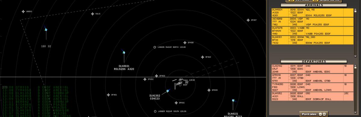
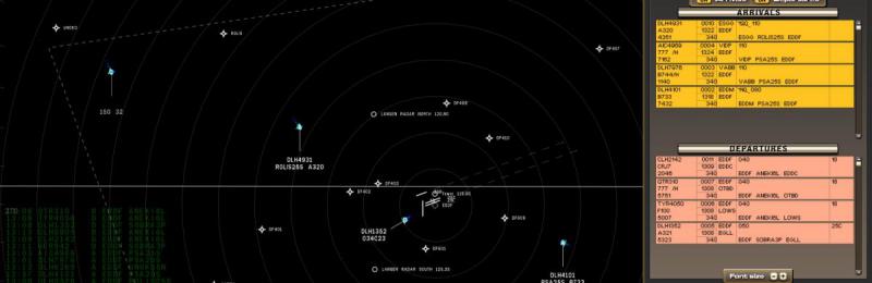
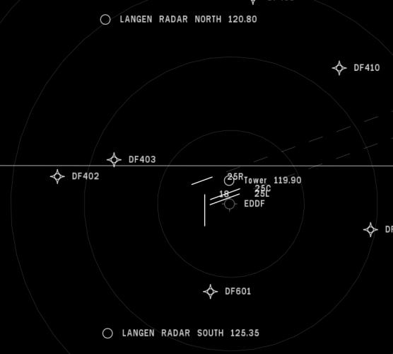
From Wikipedia: Frankfurt Airport (IATA: FRA, ICAO: EDDF) (German: Flughafen Frankfurt am Main, also known as Rhein-Main-Flughafen) is a major international airport located in Frankfurt, the fifth-largest city of Germany and one of the world's leading financial centers. It is operated by Fraport and serves as the main hub for Lufthansa including Lufthansa CityLine and Lufthansa Cargo as well as Condor and AeroLogic. The airport covers an area of 21 square kilometres (8.1 sq mi) of land and features two passenger terminals with a capacity of approximately 65 million passengers per year, four runways and extensive logistics facilities. Frankfurt Airport is by far the busiest airport by passenger traffic in Germany, the third busiest in Europe after London Heathrow Airport and Paris-Charles de Gaulle Airport and the 12th busiest worldwide in 2013.It handled 58 million passengers in 2013. With a freight throughput of 2.09 million metric tonnes in 2013 it is also the busiest airport in Europe by cargo traffic. As of winter 2012/2013, Frankfurt Airport served 264 destinations in 113 countries, making it the airport with the most international destinations in the world.
-
How soon is soon ? :razz:

-
Any news ?
-
Any news ?
-
And then there was ........ silence .......
-
Maybe this will help ? http://forum.simflight.com/topic/76185-installing-tower-and-tracon-101/
-
Try using Notepad ++ instead of the editor. See also: http://forum.simflight.com/topic/76196-tracon-2012-how-to-create-a-sector-heres-an-example/
-
Try using an editor like Notepad ++ instead of the Airspace Editor. Or take a look at this post: http://forum.simflight.com/topic/76196-tracon-2012-how-to-create-a-sector-heres-an-example/ If you need more help, PM me.
-
It looks like:
-
I hope there will be more !
-
Tracon 2012 - Looking for ATC radar history - KLAX - any suggestions?
Satch_999 replied to Japhus's topic in ATC Simulators
http://laartcc.org/page/vectoring -
Tracon: arrivals come in from center at low altitudes
Satch_999 replied to jrbright21's topic in ATC Simulators
My advice would be to use Notepad ++ for editing (http://notepad-plus-plus.org/) In this case you must make a bakup of your KJFK.asx file Then open it with Notepad ++ and look for "star route". You should see somthing like this: ( this one is taking from my own made EHAM sector) <object id="0" name="TOPPA2A" type="star route" lat="52.315399" lon="4.790200" alt="5000.000000" rot="0.000000" len="0.000000" donthide="0" params="EHAM:36L EHAM:36C EHAM:36R EHAM:18L EHAM:18C EHAM:18R EHAM:27 EHAM:09 EHAM:24 EHAM:06 EHAM:04 EHAM:22" knotsnum="0"> <section name="waypoint_to_waypoint" strlat="53.398022" strlon="3.565222" endlat="52.759289" endlon="3.745359" stralt="0.000000" strlat="53.398022" endalt="0.000000" alt="18000.000000" marker="0"/> <section name="waypoint_to_waypoint" strlat="52.759289" strlon="3.745359" endlat="52.571850" endlon="3.778223" stralt="0.000000" strlat="52.759289" endalt="0.000000" alt="15000.000000" marker="0"/> <section name="waypoint_to_waypoint" strlat="52.571850" strlon="3.778223" endlat="52.526119" endlon="3.965922" stralt="0.000000" strlat="52.571850" endalt="0.000000" alt="11000.000000" marker="0"/> Where the text is highlighted red in this post, you can change the altitude at the waypoint. -
Take a look over here: http://www.nyartcc.org/training/n90flows/NY_AirSpace.swf nyartcc.org/training/n90flows/NY_AirSpace.swf
-
Maybe it's gonne be like ........ https://www.youtube.com/watch?v=TEXcoxlpW4A ;-)
-
After seeing the execellent video "Tracon! 2012 - Arrival Management - Part 1: Principles" by Mark Hargrove ( ) i decided to make some notes. * 24R and 25L used for arrivals * VOR: 3 letters, radio beacon * Waypoints, 5 letters, fictional * 24R waypoints: JETSA-MERCE-PALAC * 25L waypoints: LIMMA-HUNDA-GAATE-FUELR * proceed direct to <waypoint> works, VOR's need to be pronouced: SLI = Seal Beach * normal configuartion = wind from west to east (west operation) * 3 categories of arrivals: North & West, South, East * South arrivals: primary runway 25L, LEENA4 * LEENA4: croos SLI at 7000, 210 knots, after SLI descend to 5000, left turn 270 for ILS approach * East arrivals: primary runway 25L, 3 stars: RIIVR2, SEAVU2 and OLDEE2 * Altitude: line above means at or below, line under means at or above * RIIVR2, waypoint RIIVR altitude between 14000 and 12000 * SEAVU2 and OLDEE2, waypoint SEAVU between 14000 and 12000 * tip about aircraft speed: keep them as long above 10000, then they can go as fast as possible * under 10000 ther's a speed maximum of 250 knots * PALAC and FUELR: cross at or above 7000 * MERCE: cross at or above 4000, left turn 220 * GAATE: cross at or above 5000, right turn 270 * ILS approaches don't fly straight in, they need an intercept heading of 20-25 degrees * North and West arrivals, primary 24R, 2 stars: SADDE6 and KIMMO2 * SADDE6: SYMON cross at 12000, BAYST cross at 10000, SMO at or above 5000, fly heading 070, just before MERCE, descent to 4000, right heading 220 for the ILS approach * KIMMO2: after PURMS right heading e.g 160, descend to 4000, right heading 225 for the ILS approach See also: http://laartcc.org/page/vectoring Good luck !
-
OK, good to hear !
-
Just wondering what the status of developement is of ATCC (coming soon .....)
-
Tracon 2012!, How to create a sector, here's an example
Satch_999 replied to Satch_999's topic in ATC Simulators
Further hints and tips: Solved the "runway problem": * Manually edited (with Notepad ++) the EHAM.asx file, and added a runway: <object id="0" name="36L" type="runway" lat="52.342773" lon="4.744292" alt="0.000000" rot="0.000000" len="6501.000000" donthide="0" params="AIRPORT:EHAM" knotsnum="0"/> * Save this file and open it with the editor * It's important that each runway has at least one SID and STAR ! It's important to have a base sector, otherwise the game will crash after a departure. Now for the next challenge: how to pair runways ? E.g. 36L and 18R. Got it ! Dragging 36L on top of 18R. STARS: You've got to set the altitude from waypoint to waypoint e.g. from 10000 to 7000 feet. Fixed the speed problem: In the xxx.apx file (where xxx = the code of the airplane), change minspeedtower="230" to minspeedtower="160". That wil get the plane to a minimum approach speed of 160 knots. -
I've created a test file, which must you get going in building sectors. A tip: use Notepad ++ to open file, in order to get the idea how to make your own sector. Paste and copy the code below in a file, and name it test.asx, place that file in your sectors directory (C:\Program Files\FeelThere\Tracon! 2012\sectors) <?xml version="1.0"?> <airspace name="NTGA" code="AAA" gmt="-1.000000" center_lat="61.254780" center_lon="12.587450" center_rot="0.000000" bgx="0.000000" bgy="0.000000" bgr="0.000000" bgs="1200.000000" wi_stab="70.000000" wi_fall="5.000000" wi_dir="90.000000" wi_forcemin="5.000000" wi_forcemax="35.000000" filter_airport="1" filter_runway="1" filter_dot line="0" filter_victor airway="0" filter_jet airway="0" filter_navigation aid="0" filter_waypoint="1" filter_terminal waypoint="0" filter_obstacle="0" filter_ils waypoint="0" filter_shoreline="0" filter_road="0" filter_sid route="0" filter_star route="0" filter_radar="0" filter_sector="0" filter_outer marker="0" filter_zla="0"> <object id="0" name="NTGA" type="airport" lat="61.243721" lon="12.619073" alt="-3.000000" rot="0.000000" len="0.000000" donthide="0" params="NAME:NTGA FREQ:123.456 G_PPH_UTC0:4 G_PPH_UTC4:10 G_PPH_UTC8:20 G_PPH_UTC12:30 G_PPH_UTC16:20 G_PPH_UTC20:10 G_ALLOW_PROP:TRUE G_ALLOW_TURBOPROP:TRUE G_ALLOW_REGIONAL_JET:TRUE G_ALLOW_NARROW_BODY_JET:TRUE G_ALLOW_WIDE_BODY_JET:TRUE " knotsnum="0"/> <object id="16611" name="18" type="runway" lat="61.258595" lon="12.513643" alt="-3.000000" rot="180.000000" len="12467.000000" donthide="0" params="AIRPORT:NTGA" knotsnum="0"/> <object id="16611" name="36" type="runway" lat="61.224072" lon="12.513711" alt="-3.000000" rot="360.000000" len="12467.000000" donthide="0" params="AIRPORT:NTGA" knotsnum="0"/> <object id="0" name="WAYPOINT A" type="waypoint" lat="61.321812" lon="12.698165" alt="5000.000000" rot="0.000000" len="0.000000" donthide="0" params="SHOW:TRUE" knotsnum="0"/> <object id="0" name="WAYPOINT B" type="waypoint" lat="61.318386" lon="12.322643" alt="5000.000000" rot="0.000000" len="0.000000" donthide="0" params="SHOW:TRUE" knotsnum="0"/> <object id="0" name="WAYPOINT C" type="waypoint" lat="61.169285" lon="12.728541" alt="5000.000000" rot="0.000000" len="0.000000" donthide="0" params="SHOW:TRUE" knotsnum="0"/> <object id="0" name="WAYPOINT D" type="waypoint" lat="61.164963" lon="12.315980" alt="5000.000000" rot="0.000000" len="0.000000" donthide="0" params="SHOW:TRUE" knotsnum="0"/> <object id="0" name="A" type="sid route" lat="61.254780" lon="12.587450" alt="5000.000000" rot="0.000000" len="0.000000" donthide="0" params="NTGA:18" knotsnum="0"> <section name="SET ME!!" strlat="61.258583" strlon="12.513943" endlat="61.321747" endlon="12.696525" stralt="0.000000" strlat="61.258583" endalt="0.000000" alt="2000.000000" marker="0"/> <section name="SET ME!!" strlat="61.321747" strlon="12.696525" endlat="61.393658" endlon="12.785049" stralt="0.000000" strlat="61.321747" endalt="0.000000" alt="2000.000000" marker="0"/> </object> <object id="0" name="B" type="sid route" lat="61.254780" lon="12.587450" alt="5000.000000" rot="0.000000" len="0.000000" donthide="0" params="NTGA:18" knotsnum="0"> <section name="SET ME!!" strlat="61.258583" strlon="12.513943" endlat="61.318703" endlon="12.321877" stralt="0.000000" strlat="61.258583" endalt="0.000000" alt="2000.000000" marker="0"/> <section name="SET ME!!" strlat="61.318703" strlon="12.321877" endlat="61.392136" endlon="12.253112" stralt="0.000000" strlat="61.318703" endalt="0.000000" alt="2000.000000" marker="0"/> </object> <object id="0" name="C" type="sid route" lat="61.254780" lon="12.587450" alt="5000.000000" rot="0.000000" len="0.000000" donthide="0" params="NTGA:36" knotsnum="0"> <section name="SET ME!!" strlat="61.223961" strlon="12.514733" endlat="61.169930" endlon="12.728931" stralt="0.000000" strlat="61.223961" endalt="0.000000" alt="2000.000000" marker="0"/> <section name="SET ME!!" strlat="61.169930" strlon="12.728931" endlat="61.118565" endlon="12.811132" stralt="0.000000" strlat="61.169930" endalt="0.000000" alt="2000.000000" marker="0"/> </object> <object id="0" name="D" type="sid route" lat="61.254780" lon="12.587450" alt="5000.000000" rot="0.000000" len="0.000000" donthide="0" params="NTGA:36" knotsnum="0"> <section name="SET ME!!" strlat="61.223961" strlon="12.513943" endlat="61.164986" endlon="12.314762" stralt="0.000000" strlat="61.223961" endalt="0.000000" alt="2000.000000" marker="0"/> <section name="SET ME!!" strlat="61.164986" strlon="12.314762" endlat="61.103348" endlon="12.274452" stralt="0.000000" strlat="61.164986" endalt="0.000000" alt="2000.000000" marker="0"/> </object> <object id="0" name="WAYPOINT E" type="waypoint" lat="61.491322" lon="11.871329" alt="5000.000000" rot="0.000000" len="0.000000" donthide="0" params="" knotsnum="0"/> <object id="0" name="WAYPOINT F" type="waypoint" lat="61.501148" lon="13.201461" alt="5000.000000" rot="0.000000" len="0.000000" donthide="0" params="" knotsnum="0"/> <object id="0" name="WAYPOINT G" type="waypoint" lat="61.006306" lon="11.872790" alt="5000.000000" rot="0.000000" len="0.000000" donthide="0" params="" knotsnum="0"/> <object id="0" name="WAYPOINT H" type="waypoint" lat="61.005604" lon="13.221854" alt="5000.000000" rot="0.000000" len="0.000000" donthide="0" params="" knotsnum="0"/> <object id="0" name="Set me!" type="star route" lat="61.254780" lon="12.587450" alt="5000.000000" rot="0.000000" len="0.000000" donthide="0" params="NTGA:18" knotsnum="0"> <section name="SET ME!!" strlat="61.534134" strlon="11.558054" endlat="61.490616" endlon="11.870081" stralt="0.000000" strlat="61.534134" endalt="0.000000" alt="5000.000000" marker="0"/> <section name="SET ME!!" strlat="61.490616" strlon="11.870081" endlat="61.321461" endlon="12.317707" stralt="0.000000" strlat="61.490616" endalt="0.000000" alt="1000.000000" marker="0"/> </object> <object id="0" name="Set me!" type="star route" lat="61.254780" lon="12.587450" alt="5000.000000" rot="0.000000" len="0.000000" donthide="0" params="NTGA:18" knotsnum="0"> <section name="SET ME!!" strlat="61.562210" strlon="13.523530" endlat="61.501144" endlon="13.201297" stralt="0.000000" strlat="61.562210" endalt="0.000000" alt="5000.000000" marker="0"/> <section name="SET ME!!" strlat="61.501144" strlon="13.201297" endlat="61.322865" endlon="12.699721" stralt="0.000000" strlat="61.501144" endalt="0.000000" alt="2000.000000" marker="0"/> </object> <object id="0" name="Set me!" type="star route" lat="61.254780" lon="12.587450" alt="5000.000000" rot="0.000000" len="0.000000" donthide="0" params="NTGA:36" knotsnum="0"> <section name="SET ME!!" strlat="60.959282" strlon="11.575551" endlat="61.006310" endlon="11.870081" stralt="0.000000" strlat="60.959282" endalt="0.000000" alt="5000.000000" marker="0"/> <section name="SET ME!!" strlat="61.006310" strlon="11.870081" endlat="61.164936" endlon="12.308959" stralt="0.000000" strlat="61.006310" endalt="0.000000" alt="2000.000000" marker="0"/> </object> <object id="0" name="Set me!" type="star route" lat="61.254780" lon="12.587450" alt="5000.000000" rot="0.000000" len="0.000000" donthide="0" params="NTGA:36" knotsnum="0"> <section name="SET ME!!" strlat="60.935417" strlon="13.625594" endlat="61.004204" endlon="13.224626" stralt="0.000000" strlat="60.935417" endalt="0.000000" alt="5000.000000" marker="0"/> <section name="SET ME!!" strlat="61.004204" strlon="13.224626" endlat="61.167744" endlon="12.727425" stralt="0.000000" strlat="61.004204" endalt="0.000000" alt="2000.000000" marker="0"/> </object> <object id="0" name="base_sector" type="sector" lat="61.254780" lon="12.587450" alt="5000.000000" rot="0.000000" len="0.000000" donthide="0" params="FREQ:333.333" knotsnum="5"> <knot x="-296548.843750" y="-170264.281250" z="0.000000"/> <knot x="-345554.781250" y="205448.031250" z="0.000000"/> <knot x="350581.031250" y="256967.093750" z="0.000000"/> <knot x="337387.156250" y="-156442.078125" z="0.000000"/> <knot x="-6282.813965" y="-277072.125000" z="0.000000"/> </object> </airspace>