Satch_999
-
Posts
79 -
Joined
-
Last visited
-
Days Won
1
Content Type
Profiles
Forums
Events
Gallery
Downloads
Everything posted by Satch_999
-
Thanks.
-
Is there a list what the SP1 fixes ?
-
Great ! I'll check this one out !
-
Well, the sooner ATC Pro is released, the sooner ARTCC comes out ! ;-)
-
Hurry hurry ! ;-) Can't wait for ARTCC !
-
http://www.feelthere.com/productFaq
-
I've send you an email back with good news !
-
Yeah Vic, you're right ! Indeed, we know us from a long time ago (Tracon!2012 EHAM sector, ATCC etc etc. ;-) )
-
I just sent you an email via the contact us button.
-
@vic Tower! 2011 (with SP2) runs fine, no problems with that.
-
Running as administrator didn't help. I think, as already stated, that my problem lies in the towerspeak.dll as you can see in the attached log file. game.log
-
OS: Windows 10 Home 64 bits RAM: 8 Gb Installed the setup as administrator, ran the tower3d.exe as administrator. Program won't go further loading than 70% Attached the log file. To me, the main problem is:"Failed to load 'C:/Program Files (x86)/FeelThere/Tower 3D/tower3d_Data/Plugins/towerspeak.dll' with error 'The specified module could not be found." The towerspeak.dll is in the correct folder. game.log
-
Removed ? Why ?
-
FeelThere, on 23 Feb 2015 - 11:01 AM, said: What happened to that post ? It's disappeared.
-
What happened to that post ? It's disappeared ?
-
Is it possible to make use of this editor ? (see attached file)
-
He is feeling better ?
-
Ok, let's rephrase the question: is it ever being released ? In other words: are you still working on it ?
-
Good luck ! Maybe you can post some screenshots ?
-
First post in this topic: Posted 24 February 2014 - 11:56 AM :???: Posted 16 December 2014 - 11:11 AM We are planning to release it Q1 2015. :cry:
-
Does that mean we have to wait for, let's say, more than a year or two ? C'mon ! The editor is working for ATCC, am i right ? So why not develop it further ?
-
Any news ?
-
Can you post a screenshot (or two ) ?
-
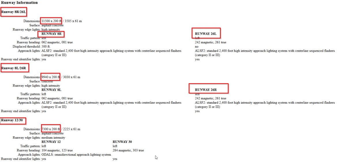
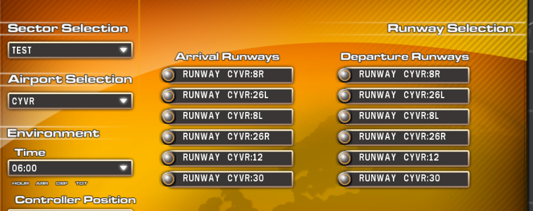
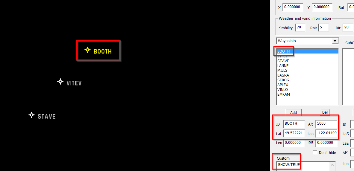
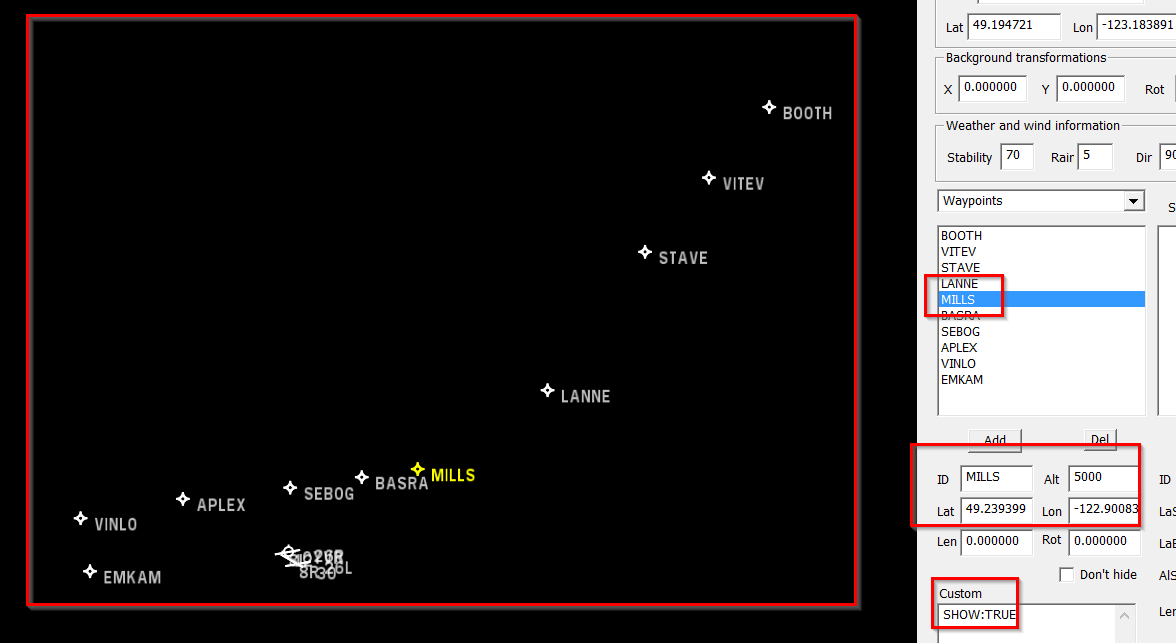
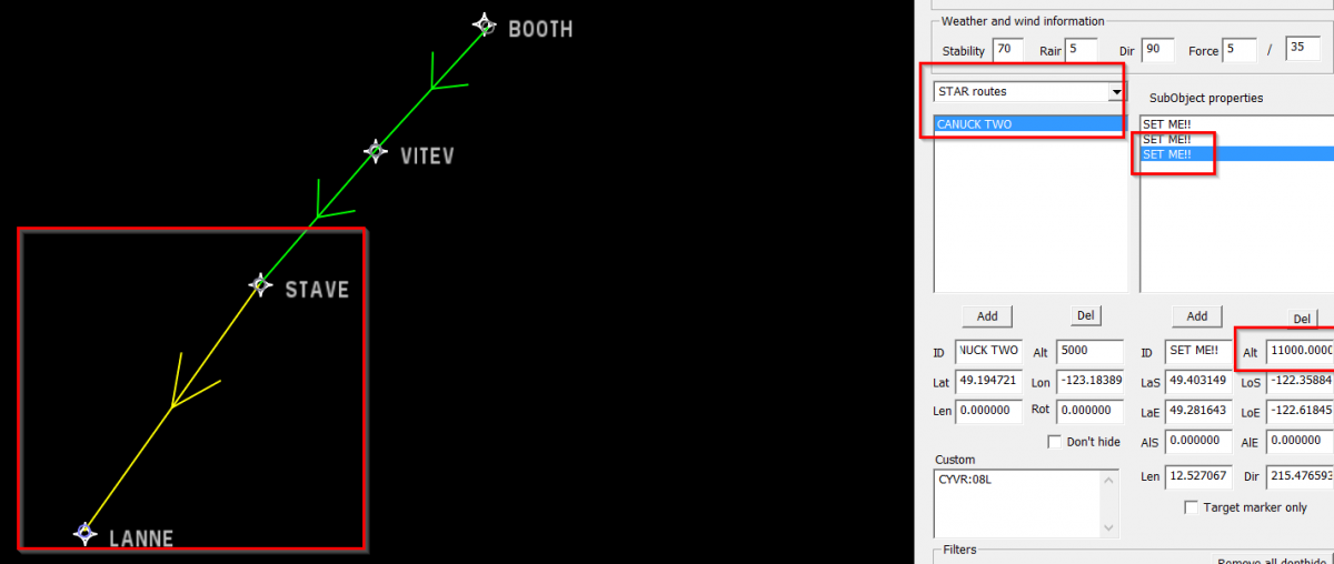
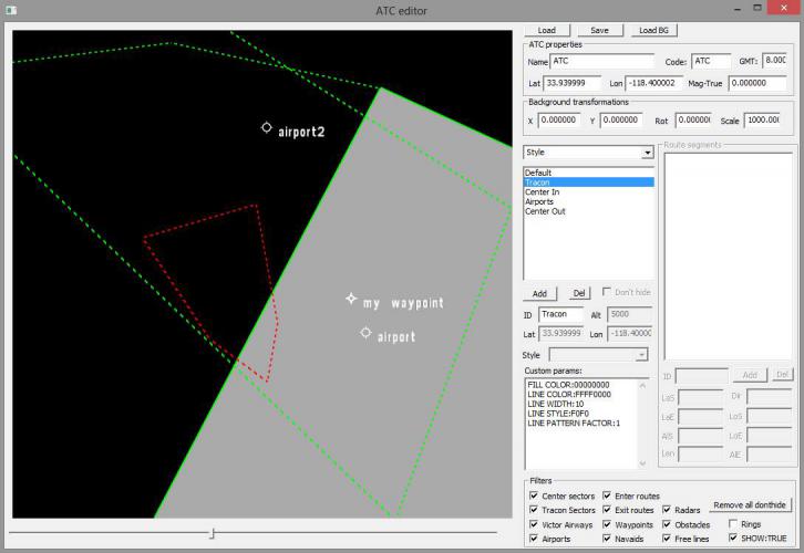
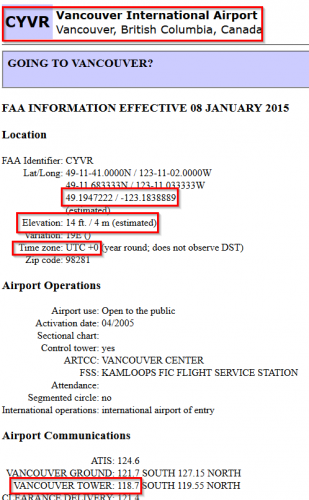
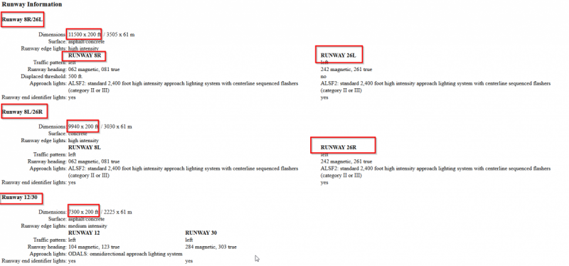
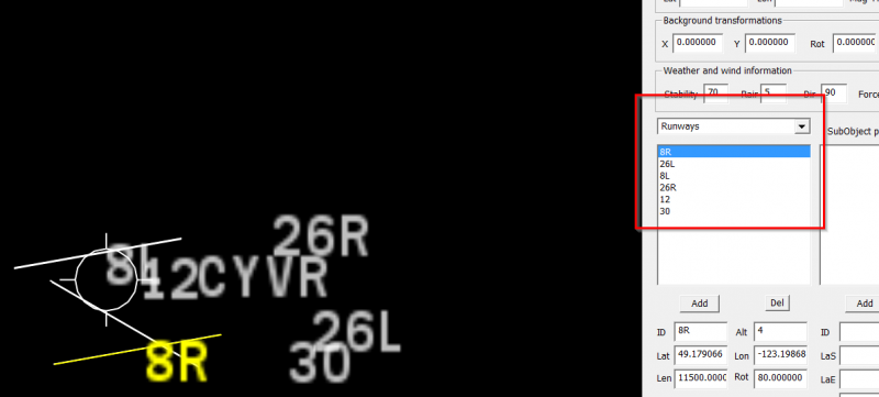
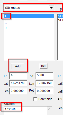
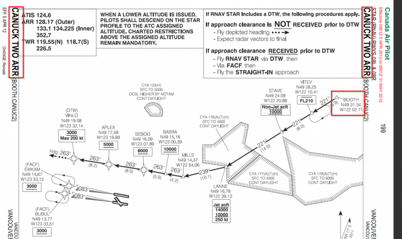
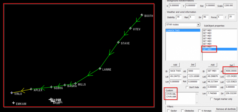
I'm trying to teach you how to make a sector file of your favorite airport. I use the test.asx base (found on this forum) and then edit this in such a way to build CYVR (Vancouver International Airport).This is done in parts, that's why it is possible that this topic is not updated for a while. Please do not reply to this topic, but rather via PM. It is also important to let the AirpaceEd.exe run as administrator. I use Notepad ++ for text editing. This is the first screen we you load the test.asx First thing to do is, get some information about the airport. I use AirNav for that, here's the basic information: http://www.airnav.com/airport/CYVR We will put that via Notepad ++ in the test.asx file (don't use the editor for this, it will crash) Make sure in the editor itself to put in a Mag-True of -19, as found in "Variation: 19E. Now, let's add the runways: These runways have to pair, 8R goes on 26L etc. I manually put these runways in Notepad ++ and then load the file in the editor. On the right side select the runways, it turns yellow. Then via a hold/left mouse click drag 8R on 26L etc. (this can be a little hard to do) It's important that each runway has at least one SID and STAR, that's why i created fictional SIDS A, B, C and D and four fictional STAR routes. We combine them with the runways, we'll have to make two SIDS and STARS by ourselves, because we have six runways. Don't worry, we will make real SID's and STARS. When we start up Tracon!2012, the airfield is showing up: Now we can make our first STAR, CANNUCK TWO To get the information, search e.g. on IVAO or VATSIM of Canada, http://www.ivao.ca/charts/cap To get the STAR working, first we must make Waypoints. These wayoints have to be converted to lat/lon, i use http://andrew.hedges.name/experiments/convert_lat_long/for that. In the test.asx there are a few fictional waypoints, you can edit these. First waypoint in the CANNUCK TWO arrival is BOOTH, then VITEV and so on. For each waypoint, convert it to lat/lon and put in in the editor. This is the final result: We can now create the STAR by clicking with the right mouse and holding/dragging it to the next waypoint. Looking at the chart, we can also put in the altitude constraints, e.g. at LANNE between 10 and 14 thousand feet, so i put 11000 in the Alt box. In the Custom field, add the runway for this STAR: This is the complete STAR for runways 08L and 08R:


-
Need testers ?